A small tidbits about NSW Sydney high school catchment

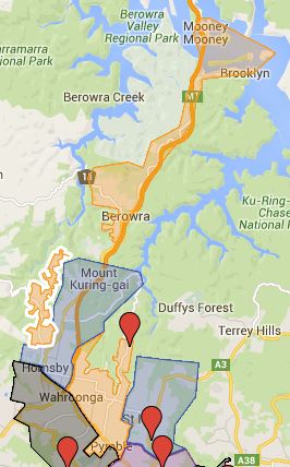
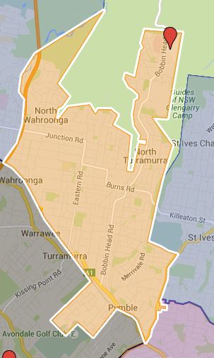
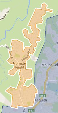
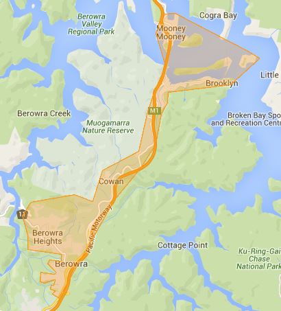
I am preparing for more high school catchment update for Sydney which I will try to keep it happening on a daily basis in the near future while the information last. In one of the previous blog I mentioned there are three types of none selective state/public high school that is Boys, Girls and Co-educational type. With Boys and Girls only high schools, they are not obligate to accept every applicants from their catchment, for example if there are only enough space for 200 and there are 400 applicants then half will miss out. The usual criteria is residential proximity to the school in question. This scenario is fairly common for the single sex schools that are in demand such as Willoughby Girls etc.

Co-educational high school however are legally obligated to accept every local applicants who lives within the school catchment. Also all catchment for Boys and Girls high school are overlaid by a catchment of Co-educational high school.

It is very difficult to create map with three different similar layers on top of each other which would make it very difficult to read. I am going to start out by splitting all three types to their own maps. Possibly in the future when I will change or merge when more elegant solution is found.

Hunters Hill High School Catchment Map

This is the school catchment map for Hunters Hill High School in Sydney, NSW.

The most common name used by NSW Department of Education is called “catchment” which refer to that students resides in particular area are guaranteed position in specific schools. When discussed from prospective of a particular school is often referred as one of the following term.

  • School Zone
  • School intake area
  • School catchment

As usual contact the school in question or Department of Education for the final confirmation and you can also access the full High School Catchment Map by following this link.

Share this post:

Ku-Ring-Gai High School

Ku-Ring-Gai Creative Arts High School Catchment added to the map, so far it is the most wonky one with three different separate zone. It is certainly getting more and more interesting. I am looking forward to more of the high schools getting added to the map.

Ku-Ring-Gai Creative Arts High School Catchment Local Drawing Area

Ku-Ring-Gai Creative Arts High School Catchment Local Drawing Area

Ku-Ring-Gai Creative Arts High School Catchment North West Drawing Area

Ku-Ring-Gai Creative Arts High School Catchment North West Drawing Area

Ku-Ring-Gai Creative Arts High School Catchment Northern Drawing Area

Ku-Ring-Gai Creative Arts High School Catchment Northern Drawing Area

The most common name used by NSW Department of Education is called “catchment” which refer to that students resides in particular area are guaranteed position in specific schools. When discussed from prospective of a particular school is often referred as one of the following term.

  • School Zone
  • School intake area
  • School catchment

As usual contact the school in question or Department of Education for the final confirmation and you can also access the full High School Catchment Map by following this link.

Share this post:

Turramurra High School Catchment Map Added

This is the school catchment map for the Turramurra High School in Sydney, NSW.

The most common name used by NSW Department of Education is called “catchment” which refer to that students resides in particular area are guaranteed position in specific schools. When discussed from prospective of a particular school is often referred as one of the following term.

  • School Zone
  • School intake area
  • School catchment

As usual contact the school in question or Department of Education for the final confirmation and you can also access the full High School Catchment Map by following this link.

Share this post:

Brief Explanation on Sydney High School Catchment Zone

The Sydney high school catchment map is about to get very funky, so I figure it is time to do a quick run down on different type of government/state high schools and its impact on the school catchment.

There are roughly four different type of secondary level government/state schools.

  1. Selective High School
  2. Girls High School
  3. Boys High School
  4. Coed High School

Selective high schools does not have specific catchment so they do not need to be taken into account when creating the map. Girls and Boys high school generally tend to have mirrored school, for example Homebush Boys and Strathfield Girls High School. These schools will have very similar catchment zones as well. Another thing is area that are under the catchment of girls and boys high schools will always be zoned for another coed high school as well. So what this means is that some address can be zoned for up to three different school.

What this also create is some really disjointed school catchments, for example refer to the St Ives High School Catchment Map that I have created yesterday. There are two distinctively separate catchment zone.

It is really hard to try accommodate three different type school catchment in one single map, even with different layers, the over lapping catchments will end up very difficult to work out. I will most likely do different map for girls, boys and coed high schools.

en_AUEnglish (Australia)