This is the 2024 update for the NSW, Sydney High School catchment map.
NSW, Sydney Public (Secondary) School Zone Map
The most common name used by the NSW Department of Education is called “catchment” which refers to those students who reside in a particular area and are guaranteed a position in specific schools. When discussed from the perspective of a particular school is often referred to as one of the following terms.
School Zone School intake area School catchment
As usual, contact the school in question or the Department of Education for the final confirmation and you can also access the full NSW and Sydney Public School Catchment Map by following this link.
Big changes are happening in the NSW school catchment in 2025. All the areas that are only covered by single-sex schools will also be covered by other Coed schools as well in 2025. The exception to this is Randwick Boys and Girls High School which will be merged instead. Single-sex school catchments that already overlap with other Coed schools currently will not be changed.
The following map is taken directly from the NSW Department of Education website. I will break it down in detail and go through impacted schools one by one.
Bass High School
Blakehurst High School
Concord High School
Condell Park High School
Dulwich High SchoolVAD
Georges River College Hurstville
Georges River College Peakhurst
Georges River College Penshurst
Georges River College Oatley Senior
Granville South CAPA High School
Holroyd High School
Kingsgrove High School
Kingsgrove North High School
Kogarah High School
Marrickville High School
Menai High School
Merrylands High School
New High School in Wentworth Point
Sir Joseph Banks High School
Strathfield South High School
The most common name used by the NSW Department of Education is “catchment” which refers to those students who reside in a particular area and are guaranteed a position in specific schools. When discussed from the perspective of a particular school is often referred to as one of the following terms.
School Zone
School intake area
School catchment
As usual contact the school in question or the Department of Education for the final confirmation and you can also access the full NSW and Sydney High School Catchment Map by following this link.
There is a small section getting transferred to Inner Sydney High School from Alexandria Park Community College in 2024.
The red-striped area is bounded by Zamia and Maddison Street to the north, South Dowling Street to the east, Crescent and Phillip Street to the south, and Young and Bourke Street to the west. This area will be transferred from Alexandria Park Community College to Inner Sydney High School in 2024. This area is relatively small in size, but looking at the map, it consists of a mix of low to medium and high-density dwellings. Examination shows there are a number of high-density residential builds, which means despite the relatively small size the population and potential impact on the enrolment size is probably significant. A minor point of interest, it is right next to the proposed new park and recreational area that is going to be cut out from Moore Park Golf Course.
The black border is the 2024 catchment boundary and the red is the 2023 boundary.
Alexandria Park Community College and Inner Sydney High School Catchment Map 2024
The most common name used by the NSW Department of Education is “catchment” which refers to those students who reside in a particular area and are guaranteed a position in specific schools. When discussed from the perspective of a particular school is often referred to as one of the following terms.
School Zone
School intake area
School catchment
As usual contact the school in question or the Department of Education for the final confirmation and you can also access the full NSW and Sydney High School Catchment Map by following this link.
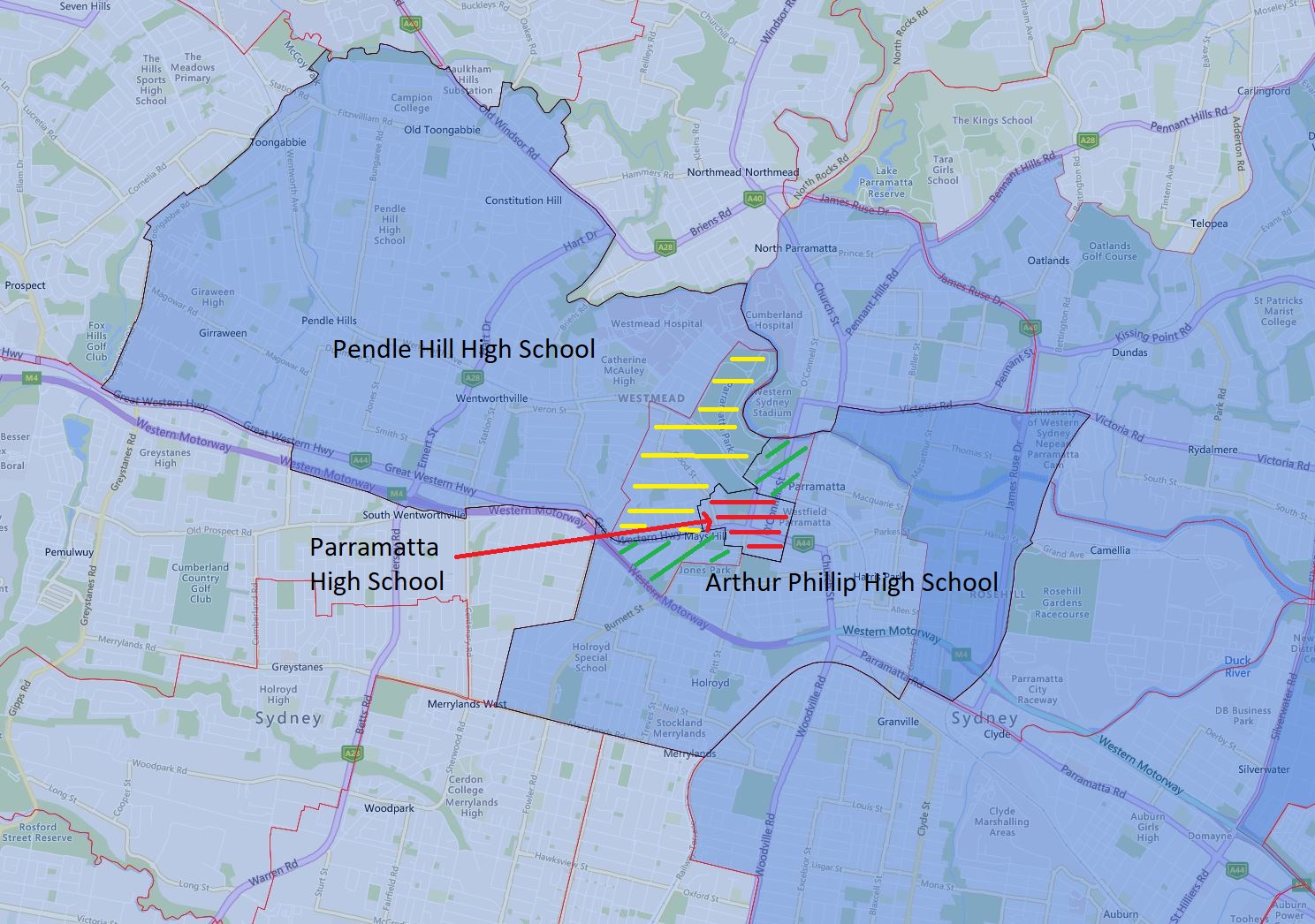
The centerpiece of this update is the dramatic shrinking of the catchment of Parramatta High School in 2024.
The red-striped area is all Parramatta High School retained in the catchment in 2024. This change is very dramatic and will result in a massive shrinking in its regular enrolment number. That being said Parramatta High School is a partial selective, so depending on the number of selective intakes, the total change may not be as dramatic as the map may suggest.
The green-striped area is transferred from Parramatta High School to Arthur Phillip High School in 2024. It is a mix of low to medium and high-density dwellings, that being said most look to be converting to higher-density residences.
The yellow-striped area is transferred from Parramatta High School to Pendle Hill High School in 2024. This is a very significant area basically everything south of the railway, east of Hawkesbury Road, and north of the Parramatta Road. It is a mix of low to medium and high-density residences as well.
The black border is the 2024 catchment boundary and the red is the 2023 boundary.
Arthur Phillip, Pendle Hill, and Parramatta High School Catchment Map 2024
The most common name used by the NSW Department of Education is “catchment” which refers to those students who reside in a particular area and are guaranteed a position in specific schools. When discussed from the perspective of a particular school is often referred to as one of the following terms.
School Zone
School intake area
School catchment
As usual contact the school in question or the Department of Education for the final confirmation and you can also access the full NSW and Sydney High School Catchment Map by following this link.
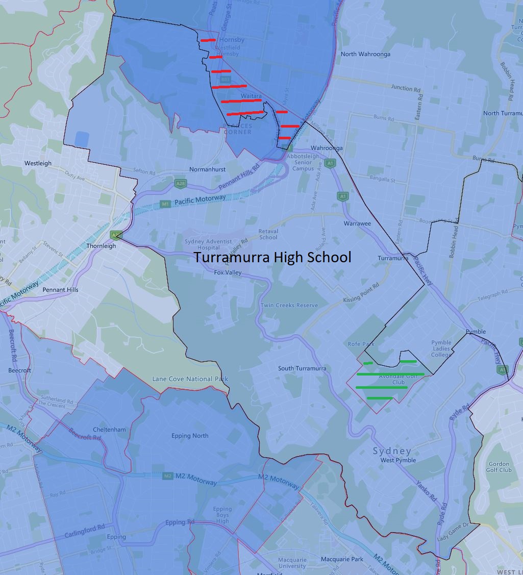
Changes are happening to the Turramurra High School catchment in 2024 along with the nearby schools as well.
The green-striped area is being transferred to Turramurra High School from Ku-ring-gai High School in 2024. I had a look at Google Maps and this area is uninhabited and will have zero impact on enrolment.
The red-striped area will be transferred away from Turramurra High to Ku-ring-gai High School in 2024. This area is situated around both sides of Pacific Highway in Hornsby and Waitara are densely populated. However, this area is a shared catchment with Asquith Boys and Girls High School, so the overall impact will be lower than the density of the population suggests. That being said this should be a pure reduction in enrolment numbers for Turramrra High School in 2024.
The black border is the 2024 catchment boundary and the red is the 2023 boundary.
Turramurra High School Catchment Map 2024
The most common name used by the NSW Department of Education is “catchment” which refers to those students who reside in a particular area and are guaranteed a position in specific schools. When discussed from the perspective of a particular school is often referred to as one of the following terms.
School Zone
School intake area
School catchment
As usual contact the school in question or the Department of Education for the final confirmation and you can also access the full NSW and Sydney High School Catchment Map by following this link.
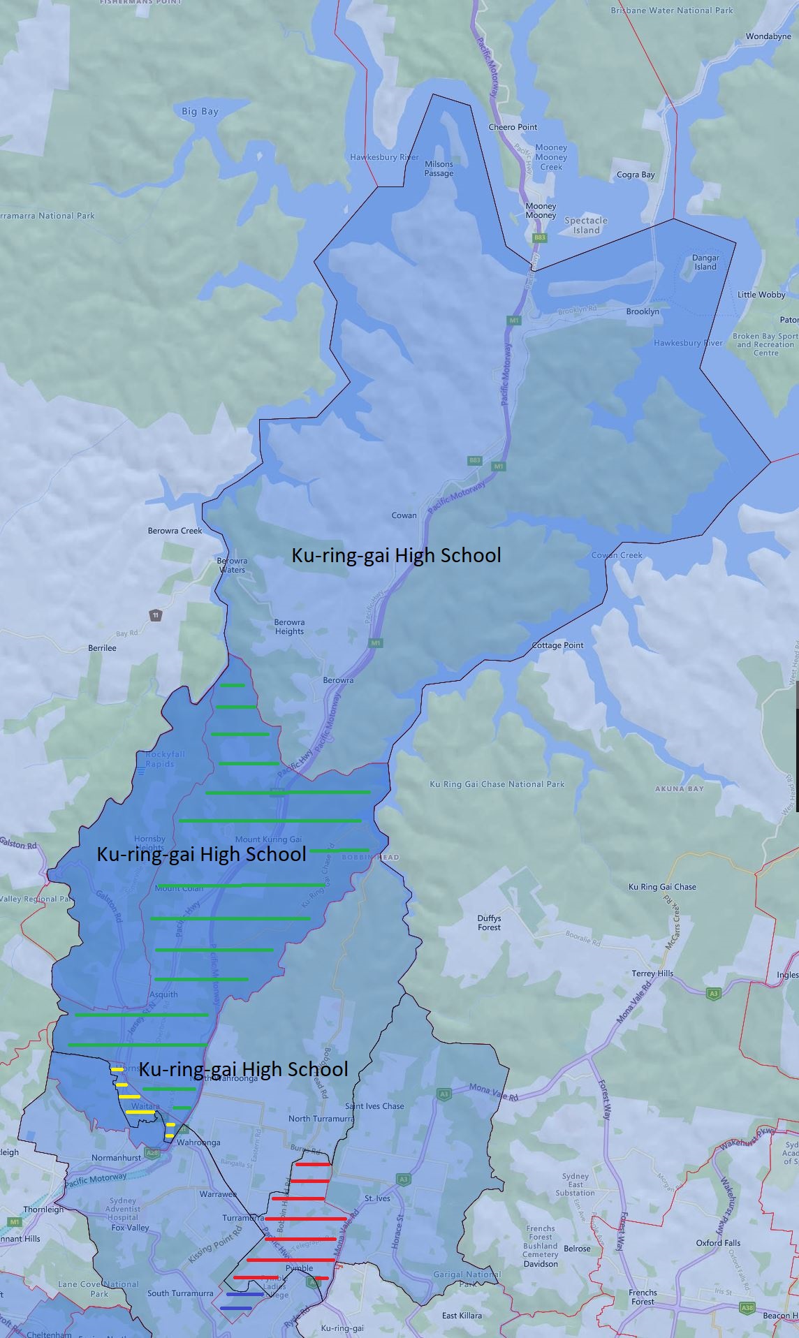
This exchange of catchment with the St Ives High School makes a lot of sense, now both school has contiguous catchment area in 2024.
The green-stripped area will be transferred from St Ives High School to the Ku-ring-gai High School catchment in 2024. This area is very significant in size, but it is overlayed with Asquith Boys and Girls High School.
The yellow-stripped area will be transferred from Turramurra High School to Ku-ring-gai High School in 2024. This area is very densely populated but again it is a shared catchment with Asquith Boys and Girls High School, so the overall impact should not be that dramatic.
The red-striped area will be transferred from Ku-ring-gai High School to St Ives High School in 2024.
The blue-striped area is being transferred from Ku-ring-gai High School to Turramurra High School in 2024, this area is very small.
Overall I think the total impact on the enrolment should be fairly neutral on a surface inspection. However, I do not know either school intimately, so this speculation could be well off the mark.
The black border is the 2024 catchment boundary and the red is the 2023 boundary.
Ku-ring-gai High School Catchment Map 2024
The most common name used by the NSW Department of Education is “catchment” which refers to those students who reside in a particular area and are guaranteed a position in specific schools. When discussed from the perspective of a particular school is often referred to as one of the following terms.
School Zone
School intake area
School catchment
As usual contact the school in question or the Department of Education for the final confirmation and you can also access the full NSW and Sydney High School Catchment Map by following this link.
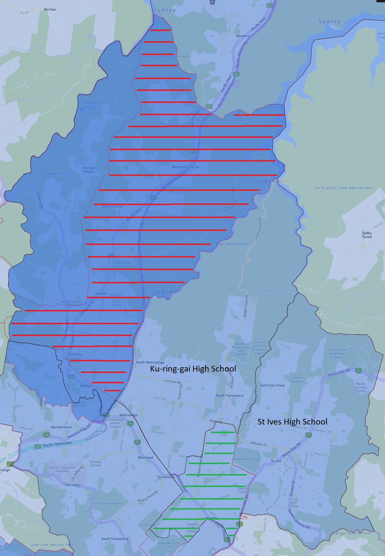
Major changes to the St Ives High School Catchment in 2024, I used to always find this catchment very unusual previously as it has most of Hornsby, Asquith, and a number of other suburbs that are significant distance away from the school itself fall under its catchment.
Now the catchment is arranged in a more logical fashion the red-striped area is transferred to Ku-ring-gai High School, please note that this area is shared with other schools.
The green-striped area will be transferred from Ku-ring-gai High School to St Ives High School in 2024. This area is connected with the existing catchment, so it will be much easier travelling-wise.
The black border is the 2024 catchment boundary and the red is the 2023 boundary.
St Ives High School Catchment Map 2024
The most common name used by the NSW Department of Education is “catchment” which refers to those students who reside in a particular area and are guaranteed a position in specific schools. When discussed from the perspective of a particular school is often referred to as one of the following terms.
School Zone
School intake area
School catchment
As usual contact the school in question or the Department of Education for the final confirmation and you can also access the full NSW and Sydney High School Catchment Map by following this link.
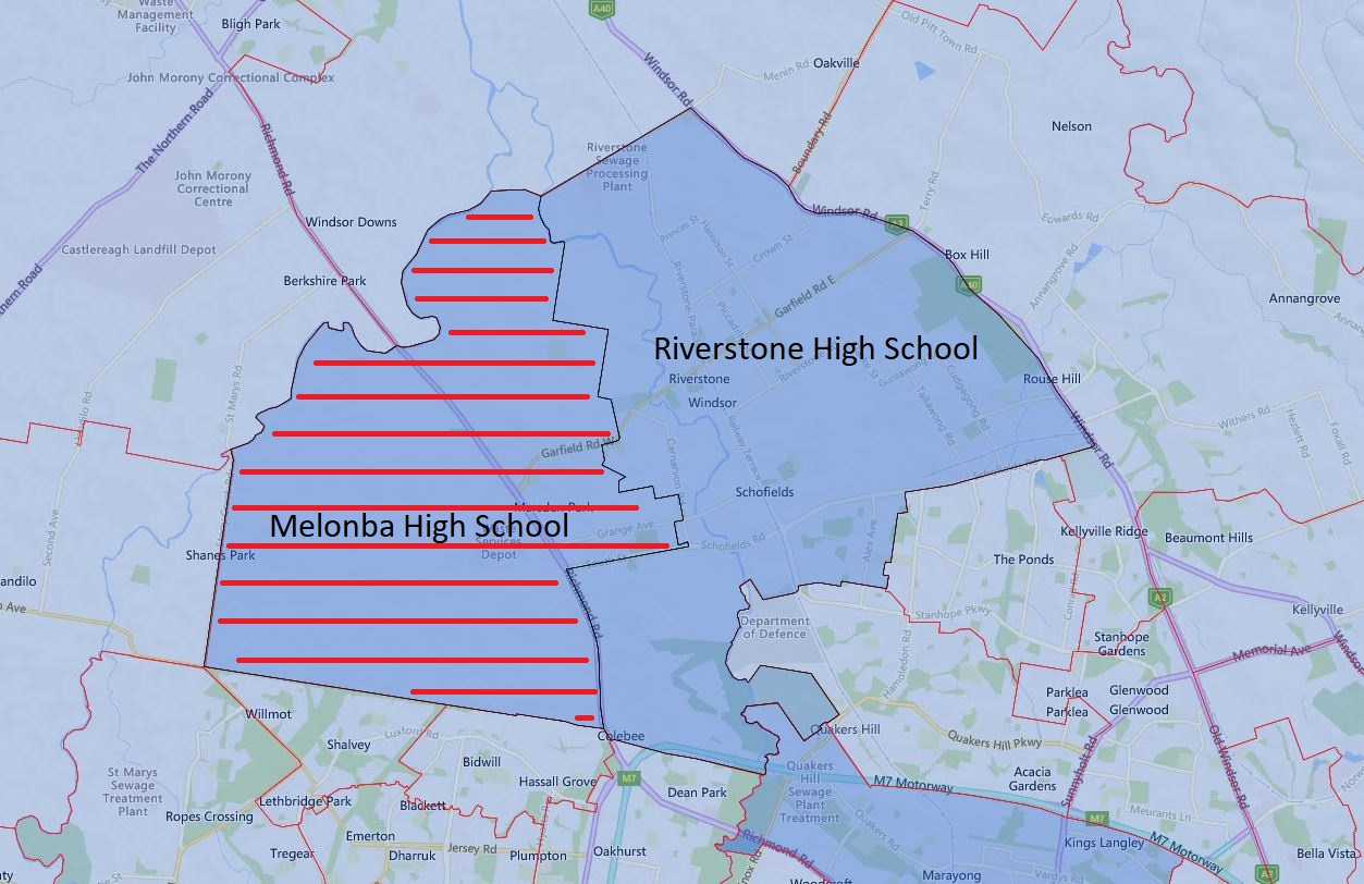
Melonba High School will open for year 7 and 8 next year. This essentially split half of the catchment off from the existing Riverstone High School in 2024.
Please note the red-striped area is what will be transferred to Melonba High School from Riverstone High School in 2024. The black border is the 2024 catchment boundary and the red is the 2023 boundary.
Melonba and Riverstone High School Catchment Map 2024
The most common name used by the NSW Department of Education is “catchment” which refers to those students who reside in a particular area and are guaranteed a position in specific schools. When discussed from the perspective of a particular school is often referred to as one of the following terms.
School Zone
School intake area
School catchment
As usual contact the school in question or the Department of Education for the final confirmation and you can also access the full NSW and Sydney High School Catchment Map by following this link.
This is the 2023 update for the NSW, Sydney High School catchment map. At the year 11 level, the changes are limited so I will not go over them in detail. For example, the new Inner City High School will only start to cover the year 11 level at the year 2024. I have spent more time cleaning up the map, this is to reduce the cluttering and make it easier to use the map. We now have the junior high school catchment on the year 11 specific version to keep it much cleaner.
NSW, Sydney Public (Secondary) School Zone Map
The most common name used by the NSW Department of Education is called “catchment” which refers to those students who reside in a particular area and are guaranteed a position in specific schools. When discussed from the perspective of a particular school is often referred to as one of the following terms.
School Zone School intake area School catchment
As usual, contact the school in question or the Department of Education for the final confirmation and you can also access the full NSW and Sydney Public School Catchment Map by following this link.
 Email This Post