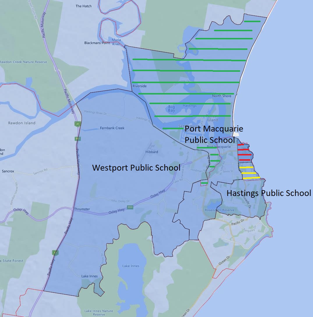
Today, I will go over the Hasting Port Macquarie and Westport Public School catchment update for 2024.
The green-striped area is what will be transferred from Westport Public School to Port Macquarie Public School in 2024
The yellow-striped area will be transferred from Port Macquarie Public School to Hastings Public School in 2024.
The red-striped area will become a shared catchment zone between Port Macquarie and Hasting Public School in 2024.
The black border is the 2024 catchment boundary and the red is the 2023 boundary.
Hasting, Port Macquarie, and Westport Public School Catchment Map
The most common name used by the NSW Department of Education is “catchment” which refers to those students who reside in a particular area and are guaranteed a position in specific schools. When discussed from the perspective of a particular school is often referred to as one of the following terms.
School Zone
School intake area
School catchment
As usual contact the school in question or the Department of Education for the final confirmation and you can also access the full NSW and Sydney Primary School Catchment Map by following this link.
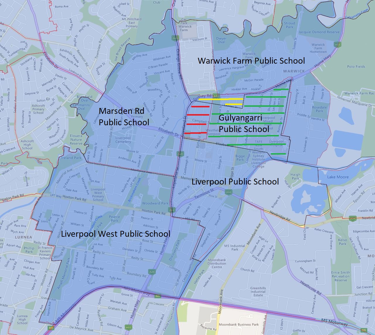
Today, I will go over the Gulyangarri, Liverpool, Marsden Road, and Warwick Farm Public School catchment update for 2024.
Everything north of Elizabeth Street is transferred away from Liverpool Public School to the Gulyangarri and Warwick Farm Public School. This area entirely consists of medium to high-density dwellings, so the impact on the enrolment number will be very significant.
Everything east of Copeland Street is being transferred from Marsden Road Public School mainly to Gulyangarri Public School with a very small block to the Warwick Farm Public School. Again this area almost entirely consists of medium to high-density dwellings.
The area is bounded by Lachland Street to the south, Bigge Street to the east, Hume Highway to the north and west, and is being transferred to the Warwick Farming Public School from Marsden Road and Liverpool Public School in 2024. This area consists of entirely medium to high-density dwellings as well.
The above three combined together will have a very significant reduction to the existing enrolment number at the Liverpool Public School in the coming years.
Please note the green-striped area is what will be transferred to the newly opened Gulyangarri Public School from Liverpool Public School in 2024. The red-striped area is what will be transferred to the newly opened Gulyangarri Public School from Marsden Public School. The yellow-striped area is what will be transferred to the Warwick Farm Public School from Marsden Road and Liverpool Public School. The black border is the 2024 catchment boundary and the red is the 2023 boundary.
Gulyangarri Public School Catchment Map 2024
The most common name used by the NSW Department of Education is “catchment” which refers to those students who reside in a particular area and are guaranteed a position in specific schools. When discussed from the perspective of a particular school is often referred to as one of the following terms.
School Zone
School intake area
School catchment
As usual contact the school in question or the Department of Education for the final confirmation and you can also access the full NSW and Sydney Primary School Catchment Map by following this link.
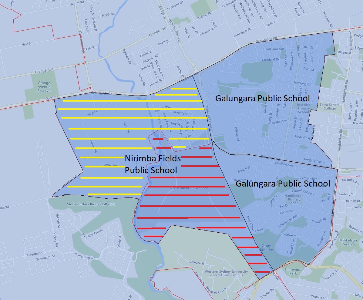
Today, I will go over the Galungara, Hambledon, and Nirimba Fields Public School catchment update for 2024.
Everything west of the railway of the existing Galungara Public School catchment was transferred to the newly opened Nirimba Fields Public School in 2024. This area is marked in yellow strips in the image below.
The Department of Defense site west of the railway is also transferred from Hambledon Public School to Nirimba Fields Public School in 2024. This area is marked in red strips in the image below.
The black border is the 2024 catchment boundary and the red is the 2023 boundary.
Galungara, Hambledon, and Nirimba Fields Public School Catchment Map 2024
The most common name used by the NSW Department of Education is “catchment” which refers to those students who reside in a particular area and are guaranteed a position in specific schools. When discussed from the perspective of a particular school is often referred to as one of the following terms.
School Zone
School intake area
School catchment
As usual contact the school in question or the Department of Education for the final confirmation and you can also access the full NSW and Sydney Primary School Catchment Map by following this link.
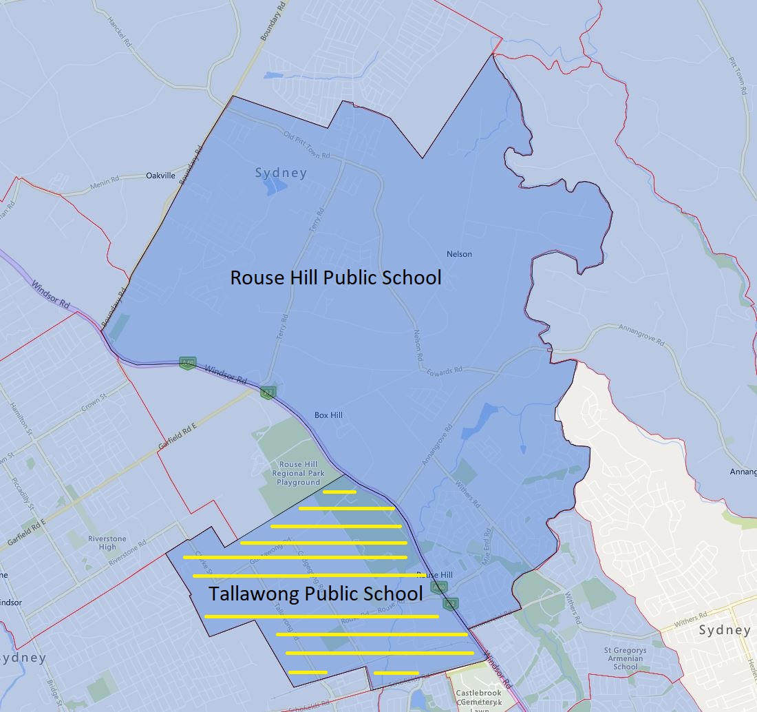
Today, I will go over Rouse Hill and Tallawong Public School and its new catchment for 2024.
The area west of Windsor Road will now become part of the new public school Tallawong Public School in 2024
This area consists of a number of medium-density dwellings and around low number of single dwellings. This will likely be ready to cater for further construction and completion of medium-density dwellings in the area.
Please note the yellow-striped area is what will be transferred to the Tallawong Public School from Rouse Hill Public School in 2024. The black border is the 2024 catchment boundary and the red is the 2023 boundary.
Rouse Hill and Tallawong Public School Catchment Map 2024
The most common name used by the NSW Department of Education is “catchment” which refers to those students who reside in a particular area and are guaranteed a position in specific schools. When discussed from the perspective of a particular school is often referred to as one of the following terms.
School Zone
School intake area
School catchment
As usual contact the school in question or the Department of Education for the final confirmation and you can also access the full NSW and Sydney Primary School Catchment Map by following this link.
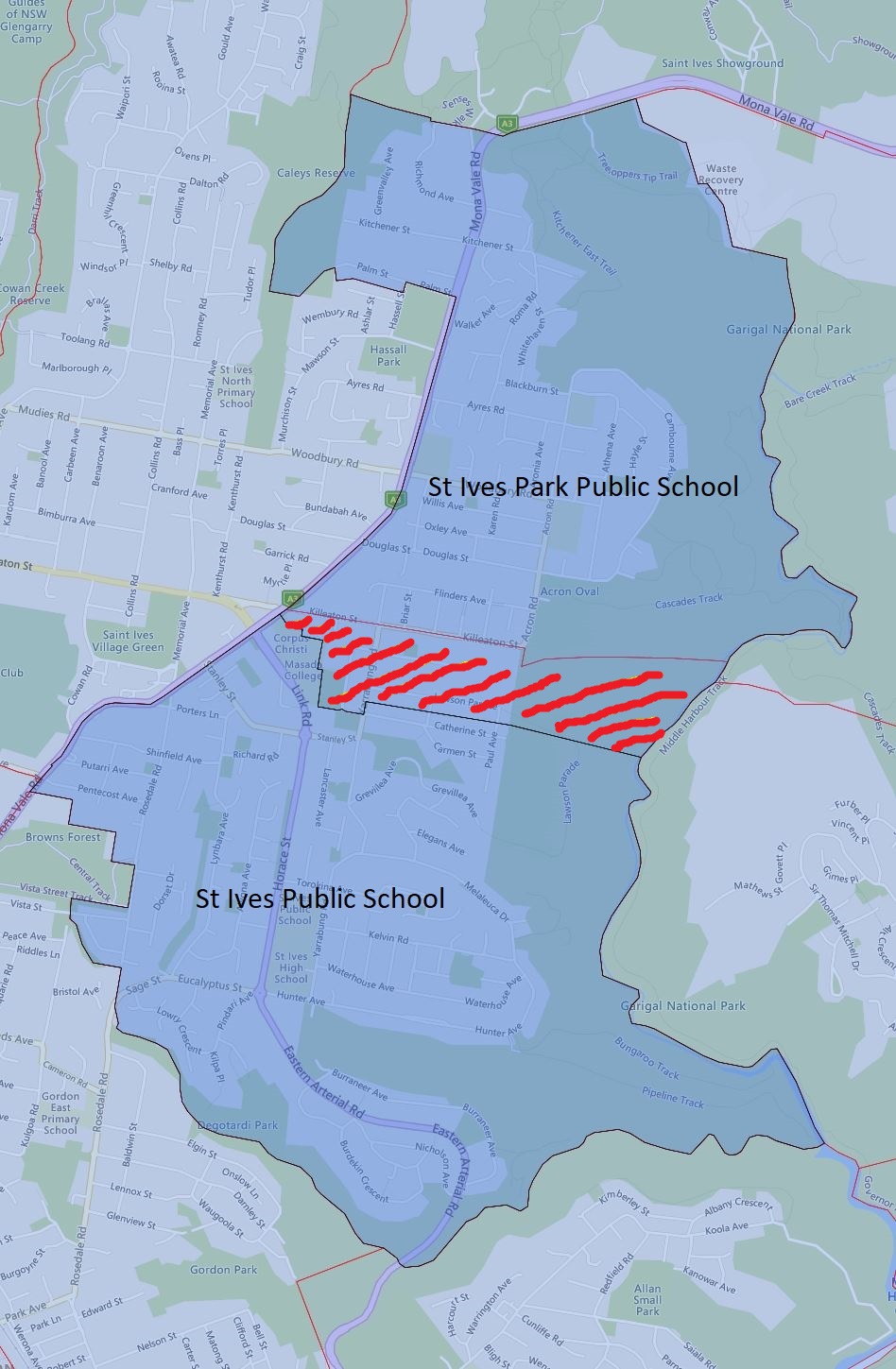
Today, I will go over St Ives Park and St Ives Public School and its new catchment for 2024.
The area north of Lawson Parade including both sides of this street up to the Killeaton street has been transferred from St Ives Public School to St Ives Park Public School in 2024.
This area consists fair number of medium-density dwellings and around 100 single dwellings. This will be a fairly significant transfer of enrolment area population-wise.
Please note the red-striped area is what will be transferred to the St Ives Park Public School from St Ives Public School in 2024. The black border is the 2024 catchment boundary and the red is the 2023 boundary.
St Ives Park Public School 2024
The most common name used by the NSW Department of Education is “catchment” which refers to those students who reside in a particular area and are guaranteed a position in specific schools. When discussed from the perspective of a particular school is often referred to as one of the following terms.
School Zone
School intake area
School catchment
As usual contact the school in question or the Department of Education for the final confirmation and you can also access the full NSW and Sydney Primary School Catchment Map by following this link.
Recent news has confirmed that Randwick Boys and Girls High School will officially merge, a decision that has been in the works for some time but was only recently made official. Over the past few decades, girls’ high schools have consistently remained more popular than their boys’ counterparts. As a result, many boys’ high schools have closed while their corresponding girls’ high schools continue to thrive. Additionally, several boys’ high schools have faced issues with low enrolment.
While this decision is not well-received by some students and parents at Randwick Girls High School, it appears to be a logical solution that will allow for more efficient use of existing facilities. The school catchments of both schools already overlap, so there should be minimal impact on enrolment.
Furthermore, there are several other potential candidates for similar mergers within the education system.
Ashfield Boys and Burwood Girls High School
Asquith Boys and Girls High School
Balgowlah Boys and Mackellar Girls High School
Bankstown Girls and Punchbowl Boys High School
Belmore Boys and Wiley Park Girls High School
Birrong Boys and Girls High School
Blacktown Boys and Girls High School
Canterbury Boys and Girls High School
East Hills Boys and Girls High School
Epping Boys and Cheltenham Girls High School
Granville Boys and Auburn Girls High School
Homebush Boys and Strathfield Girls High School
Hurstville Boys and Penshurst Girls High School
James Cook Boys Technology and Moorefield Girls High School
Liverpool Boys and Girls High School
There are a number of stand-alone girls’ high schools such as Willoughby Girls High School which overlaps a number of other co-ed high schools. I do not foresee any changes to these schools in the near future.
The most common name used by the NSW Department of Education is “catchment” which refers to those students who reside in a particular area and are guaranteed a position in specific schools. When discussed from the perspective of a particular school is often referred to as one of the following terms.
School Zone
School intake area
School catchment
As usual contact the school in question or the Department of Education for the final confirmation and you can also access the full NSW and Sydney High School Catchment Map by following this link.
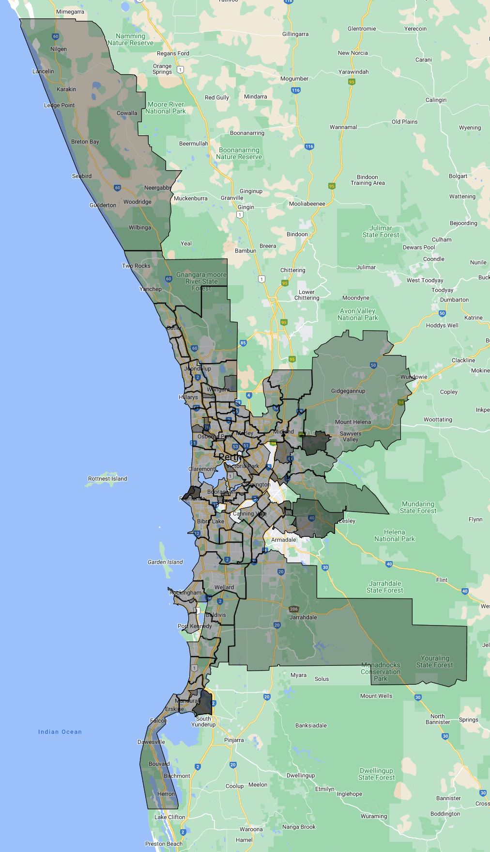
Only one new school was added this year which is Piara Waters Senior High School. I will also try to expand the coverage to the rest of the state where appropriate.
2023 Western Australia, Perth Secondary School Local Intake Area Map
2022 Western Australia, Perth Secondary School Local Intake Area Map
As usual contact the school in question for the final confirmation.
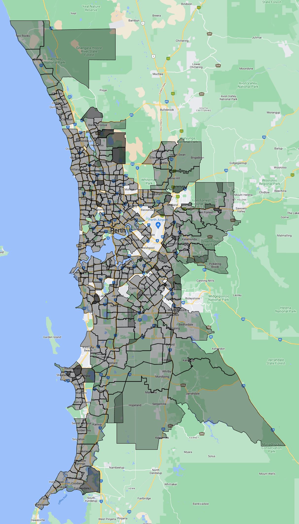
A new year and new update, I have updated and added catchment maps around fourty new and existing primary schools. The Mandurah region is now covered as well.
2023 Western Australia, Perth Primary School Local Intake Area (Catchment) Map
As usual contact the school in question for the final confirmation.
This is the update for the 2023 Queensland, Brisbane Junior Secondary School catchment.
2023 Queensland, Brisbane Junior Secondary School Catchment
The most common name used by the Queensland Department of Education is called “catchment” which refers to those students who reside in a particular area who are guaranteed a position in specific schools. When discussed from the perspective of a particular school is often referred to as one of the following terms.
School Zone
School intake area
School catchment
As usual, contact the school in question for the final confirmation.
 Email This Post