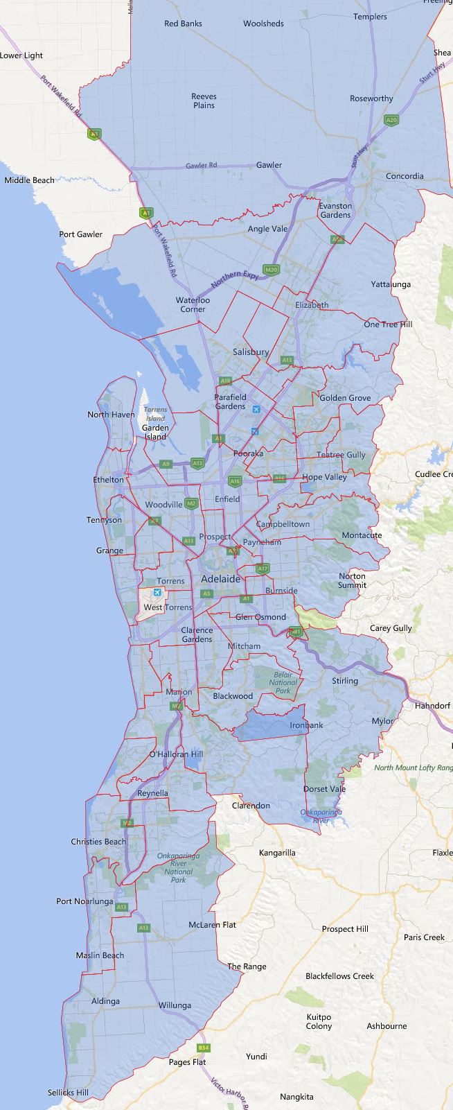
2023 South Australia, Adelaide Secondary School Zone Map Update

Not a lot of changes for the 2023 catchment again, there are some to the east of Adelaide CBD, I will try to detail them later if time permits

2023 South Australia, Adelaide Secondary School Zone Map

The most common name used by the South Australian Department of Education is called “catchment” which refers to those students who reside in a particular area and are guaranteed a position in specific schools. When discussed from the perspective of a particular school is often referred to as one of the following terms.

  • School Zone
  • School intake area
  • School catchment

As usual, contact the school in question for the final confirmation.

Share this post:

Email This Post Email This Post

2022 South Australia, Adelaide Secondary School Zone Map Update

Not a lot of changes for the 2022 catchment, only two new schools were added which are Riverbanks College B-12 which overlap with Angle Vale Primary School, and Aldinga Payinthi College which overlaps with Aldinga Beach B-7 School. There is accompanying expansion of its catchment, but both are not massive.

2022 South Australia, Adelaide Secondary School Zone Map

The most common name used by the South Australian Department of Education is called “catchment” which refers to those students who reside in a particular area and are guaranteed a position in specific schools. When discussed from the perspective of a particular school is often referred to as one of the following terms.

  • School Zone
  • School intake area
  • School catchment

As usual, contact the school in question for the final confirmation.

Share this post:

Email This Post Email This Post

2021 South Australia, Adelaide Secondary School Zone Map Update

This map is updated for 2021 and there are only two sets of changes first is Pasadena High School has been merged into Unley High School. Second is Adelaide and Adelaide Botanic High School has taken over southern part of Roma Mitchell Secondary College and northwestern part of Norwood Morialta High School zone.

Other than above there had been no changes in the last two years.

2021 South Australia, Adelaide Secondary School Zone Map

Please note there are a number of different ways the term school zone is referred, they can be also called school catchment, intake areas etc. Some of the schools have defined school zone, while the others are based on the closest distance between the student’s resident to the nearest school.

For the final confirmation please contact the school in question and you can find the Full South Australian Primary School Zone Map by following this link.

Share this post:

Email This Post Email This Post

South Australia High School Catchment Zone Map

I had a brief going over of South Australia’s high school catchment map recently.  Look like the entire Adelaide city is covered with specific zoning at secondary school level. So I have created the maps based on the information available on South Australia Department for Education and Child Development.

2017 South Australia Adelaide High School Zoning

The actual map

For final confirmation on school zoning please contact the school in question.

Share this post:

South Australia School Zoning

I have done fairly extensive work on Victoria and NSW zoning has done articles on how the zoning works in those particular states. This one I will do a quick over in South Australia on how school zoning is defined here. I had a brief look and

  1. A number of schools at both primary and secondary level are defined with specific school zones. This is very similar to other defined school zones in other states as well, however from the brief experience I had looking at this zones, overlapping seems to be fairly common in South Australia and Victoria, not so much in rest of the states. The majority of the schools fall into #2 and #3.
  2. Families residing in the greater metropolitan area may be located in an ‘unzoned’ area. Students who live in ‘unzoned’ areas will be allocated to their closest school.
  3. Where the student lives more than 5 kilometers from the nearest school and lives in an ‘unzoned’ area, the allocated school is the school serviced by a DECD-provided school bus service.

DECD stands for Department for Education and Child Development in South Australia. What I can find on the DECD’s website does not specify about any metropolitan school zones. I am assuming they also follow the similar pattern in #2 and #3 above, but with larger distance or no distance constraint. This, of course, need to be confirmed by the South Australian Department of Education.

Share this post:

Back From Holiday And Quick Status Update

I just got back from holiday and got back into working on the school catchment maps again. I have completed reworking the Melbourne primary school zone map and it is to my knowledge the most accurate available now. I had to scrap a lot of work that had been done for the South Australian primary school zone map and restarted the work again. I have began the process again and parts of previous work can be reused, so this is not a complete waste, however I probably won’t be able to finish it until late this month.

Anyhow I wish your guys all had a good holiday and restart of the normal work life is not too painful.

Progress Update On Creation of South Australia School Zone Map

Just a quick update, I have the basic all done now. However there are still fair bit of work to be done, much more so than I expected. I planned to finish by now already, but looking at the amount of things to be done, it will take at least one more week. However this will be my first statewide school zone map at primary level for the entire state.

I actually started mapping the school zones of primary schools in South Australia more than one year ago. Unfortunately various of other projects came and go, I was never able to fully complete it. Once I finished Melbourne primary school zone map, I decided to make a push and complete what I started so long ago. Anyhow enough mumbling and time to get back to finishing the map.

What is coming up next

I have now completed mapping the primary school zone map for Melbourne, Victoria. Now it is time to move onto the next target. I can now say that I am working on the mapping the primary school zone/catchment for entire South Australia. I am about 80 percent done now and hopefully will be able to complete it soon. As a consequence, the site will be lacking in updates for the next few days until complete this and make it available.

The current plan is after South Australia, I will move to Western Australia, however that is much lower degree of completion and will take much longer to be done. Anyhow see your guys in a few days, unless something big come up, however hopefully some good stuff at end of this.

en_AUEnglish (Australia)