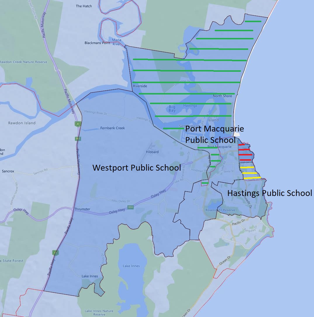
Today, I will go over the Hasting Port Macquarie and Westport Public School catchment update for 2024.
The green-striped area is what will be transferred from Westport Public School to Port Macquarie Public School in 2024
The yellow-striped area will be transferred from Port Macquarie Public School to Hastings Public School in 2024.
The red-striped area will become a shared catchment zone between Port Macquarie and Hasting Public School in 2024.
The black border is the 2024 catchment boundary and the red is the 2023 boundary.
Hasting, Port Macquarie, and Westport Public School Catchment Map
The most common name used by the NSW Department of Education is “catchment” which refers to those students who reside in a particular area and are guaranteed a position in specific schools. When discussed from the perspective of a particular school is often referred to as one of the following terms.
School Zone
School intake area
School catchment
As usual contact the school in question or the Department of Education for the final confirmation and you can also access the full NSW and Sydney Primary School Catchment Map 通过点击此链接。
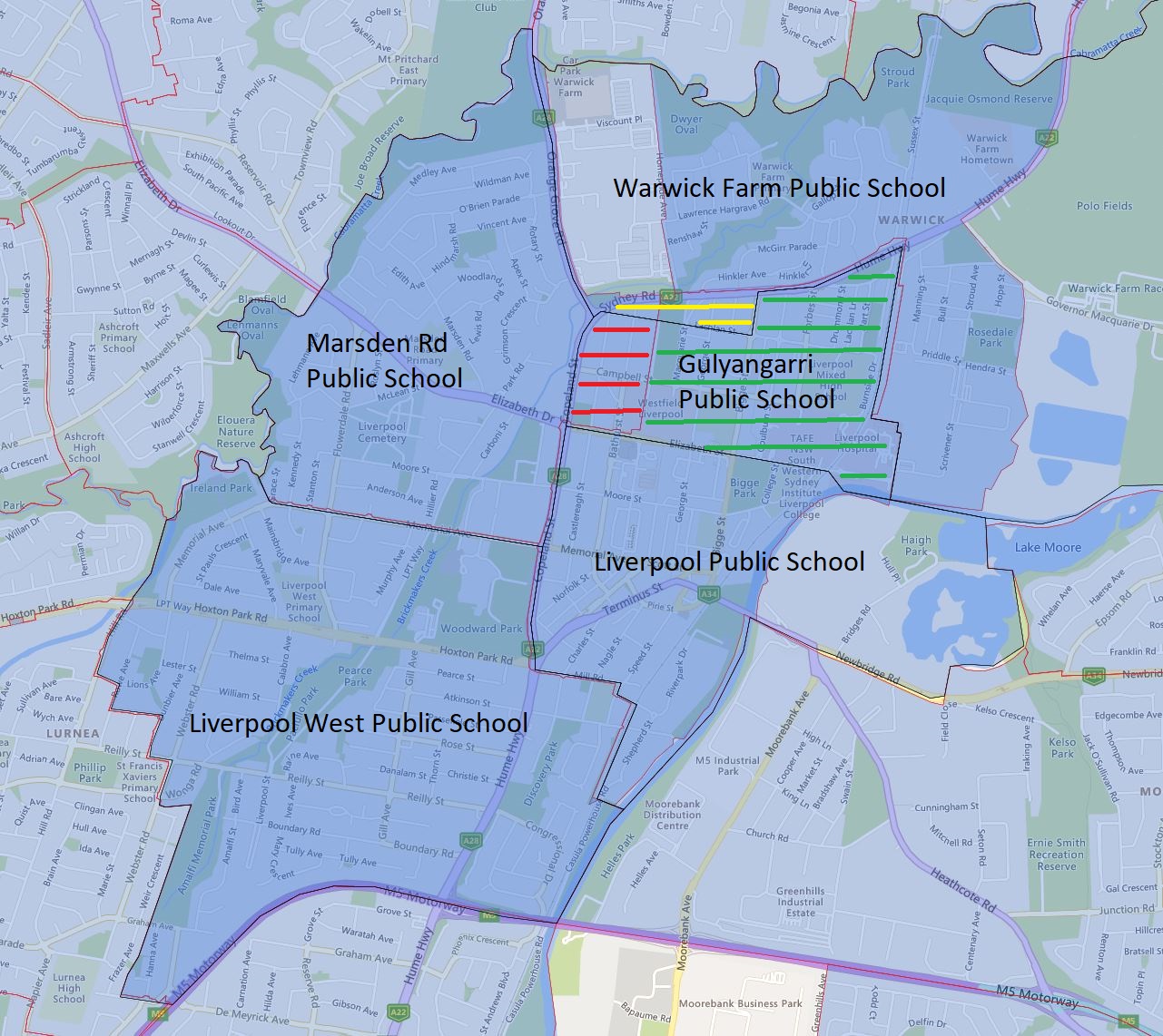
Today, I will go over the Gulyangarri, Liverpool, Marsden Road, and Warwick Farm Public School catchment update for 2024.
Everything north of Elizabeth Street is transferred away from Liverpool Public School to the Gulyangarri and Warwick Farm Public School. This area entirely consists of medium to high-density dwellings, so the impact on the enrolment number will be very significant.
Everything east of Copeland Street is being transferred from Marsden Road Public School mainly to Gulyangarri Public School with a very small block to the Warwick Farm Public School. Again this area almost entirely consists of medium to high-density dwellings.
The area is bounded by Lachland Street to the south, Bigge Street to the east, Hume Highway to the north and west, and is being transferred to the Warwick Farming Public School from Marsden Road and Liverpool Public School in 2024. This area consists of entirely medium to high-density dwellings as well.
The above three combined together will have a very significant reduction to the existing enrolment number at the Liverpool Public School in the coming years.
Please note the green-striped area is what will be transferred to the newly opened Gulyangarri Public School from Liverpool Public School in 2024. The red-striped area is what will be transferred to the newly opened Gulyangarri Public School from Marsden Public School. The yellow-striped area is what will be transferred to the Warwick Farm Public School from Marsden Road and Liverpool Public School. The black border is the 2024 catchment boundary and the red is the 2023 boundary.
Gulyangarri Public School Catchment Map 2024
The most common name used by the NSW Department of Education is “catchment” which refers to those students who reside in a particular area and are guaranteed a position in specific schools. When discussed from the perspective of a particular school is often referred to as one of the following terms.
School Zone
School intake area
School catchment
As usual contact the school in question or the Department of Education for the final confirmation and you can also access the full NSW and Sydney Primary School Catchment Map 通过点击此链接。
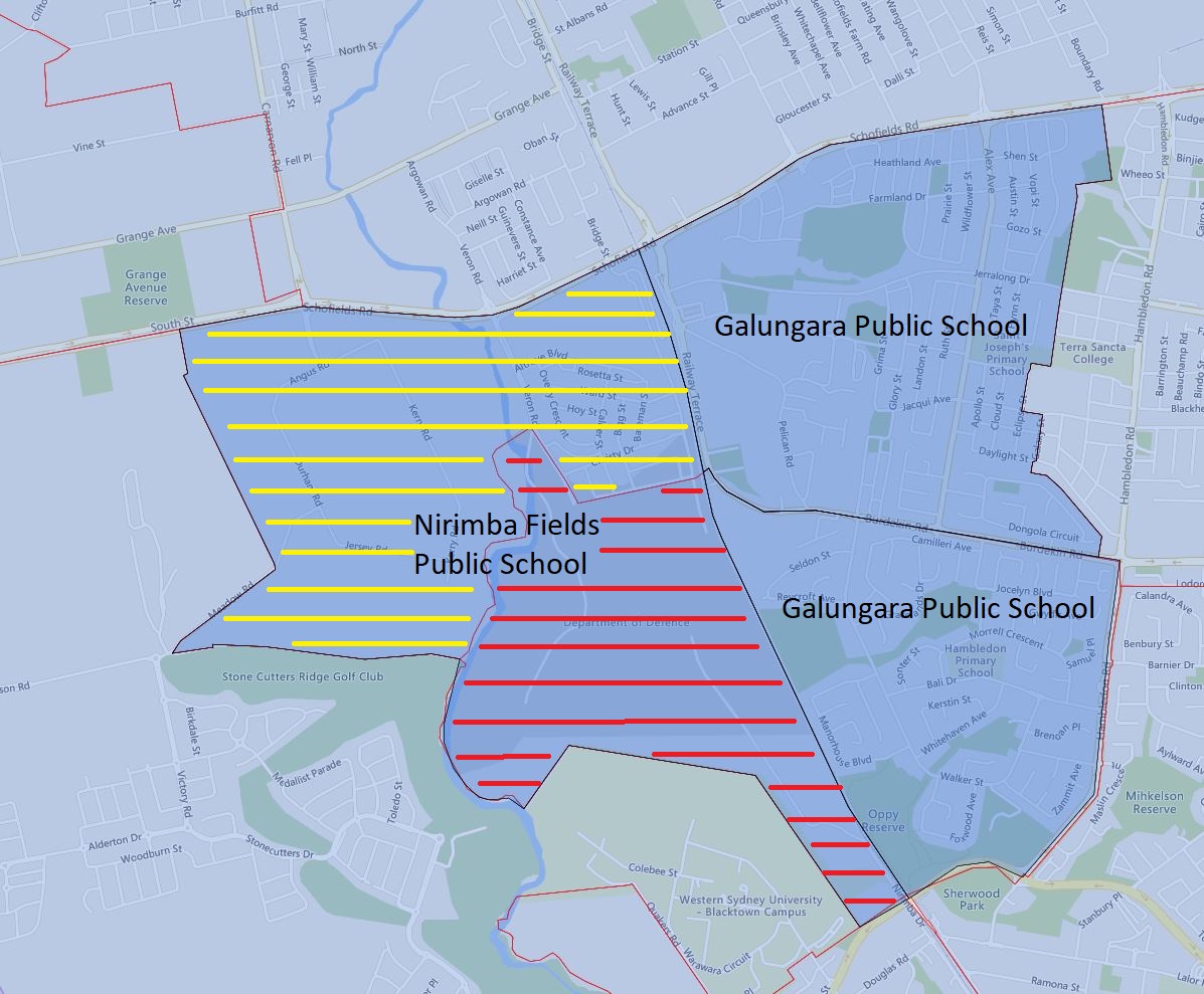
Today, I will go over the Galungara, Hambledon, and Nirimba Fields Public School catchment update for 2024.
Everything west of the railway of the existing Galungara Public School catchment was transferred to the newly opened Nirimba Fields Public School in 2024. This area is marked in yellow strips in the image below.
The Department of Defense site west of the railway is also transferred from Hambledon Public School to Nirimba Fields Public School in 2024. This area is marked in red strips in the image below.
The black border is the 2024 catchment boundary and the red is the 2023 boundary.
Galungara, Hambledon, and Nirimba Fields Public School Catchment Map 2024
The most common name used by the NSW Department of Education is “catchment” which refers to those students who reside in a particular area and are guaranteed a position in specific schools. When discussed from the perspective of a particular school is often referred to as one of the following terms.
School Zone
School intake area
School catchment
As usual contact the school in question or the Department of Education for the final confirmation and you can also access the full NSW and Sydney Primary School Catchment Map 通过点击此链接。
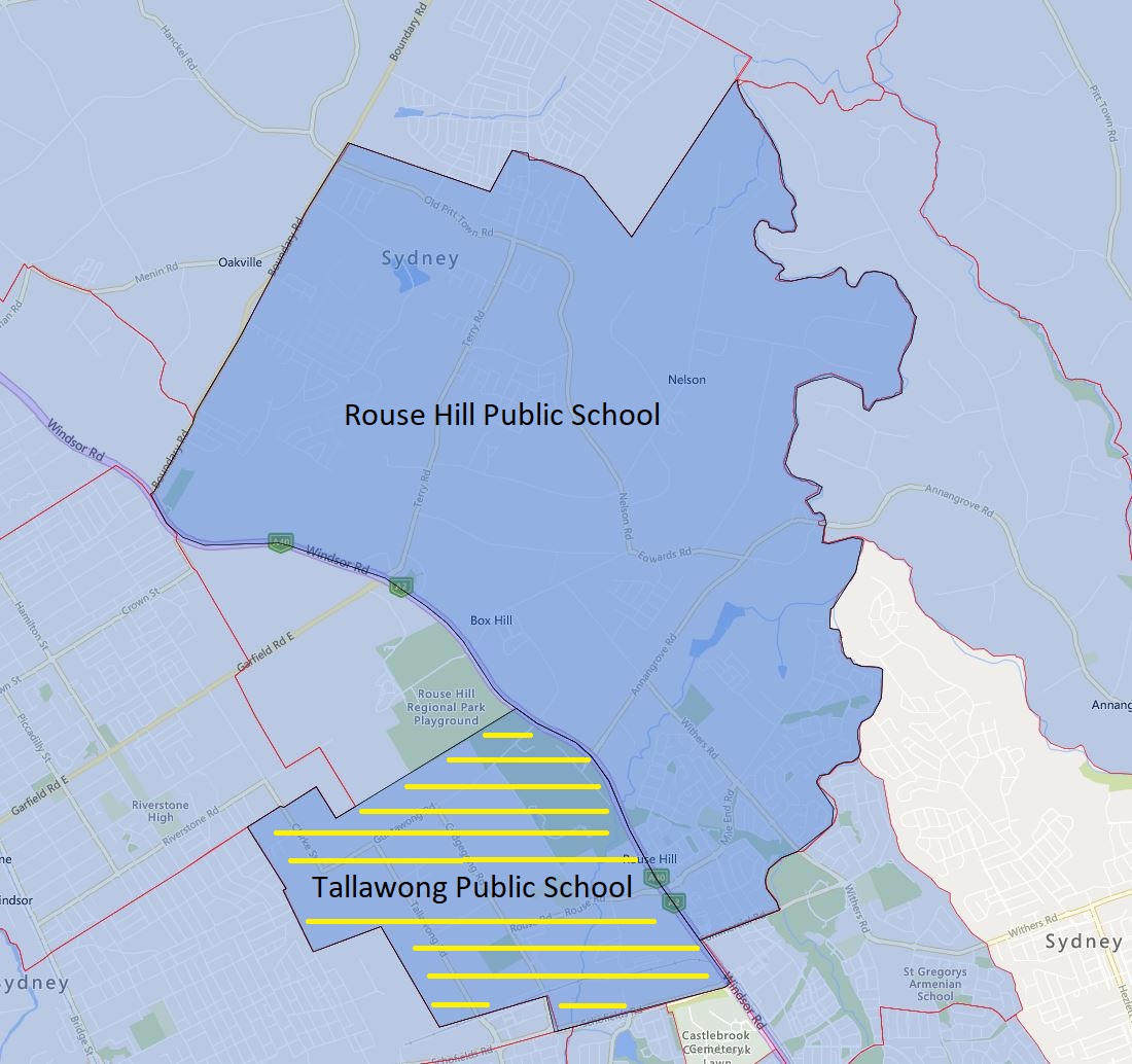
Today, I will go over Rouse Hill and Tallawong Public School and its new catchment for 2024.
The area west of Windsor Road will now become part of the new public school Tallawong Public School in 2024
This area consists of a number of medium-density dwellings and around low number of single dwellings. This will likely be ready to cater for further construction and completion of medium-density dwellings in the area.
Please note the yellow-striped area is what will be transferred to the Tallawong Public School from Rouse Hill Public School in 2024. The black border is the 2024 catchment boundary and the red is the 2023 boundary.
Rouse Hill and Tallawong Public School Catchment Map 2024
The most common name used by the NSW Department of Education is “catchment” which refers to those students who reside in a particular area and are guaranteed a position in specific schools. When discussed from the perspective of a particular school is often referred to as one of the following terms.
School Zone
School intake area
School catchment
As usual contact the school in question or the Department of Education for the final confirmation and you can also access the full NSW and Sydney Primary School Catchment Map 通过点击此链接。
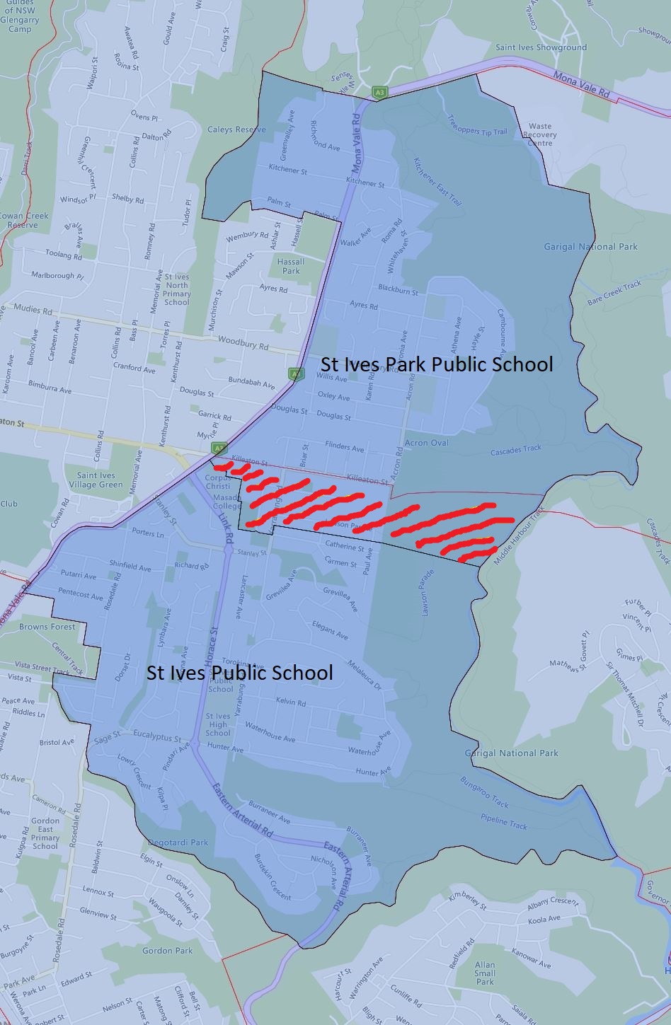
Today, I will go over St Ives Park and St Ives Public School and its new catchment for 2024.
The area north of Lawson Parade including both sides of this street up to the Killeaton street has been transferred from St Ives Public School to St Ives Park Public School in 2024.
This area consists fair number of medium-density dwellings and around 100 single dwellings. This will be a fairly significant transfer of enrolment area population-wise.
Please note the red-striped area is what will be transferred to the St Ives Park Public School from St Ives Public School in 2024. The black border is the 2024 catchment boundary and the red is the 2023 boundary.
St Ives Park Public School 2024
The most common name used by the NSW Department of Education is “catchment” which refers to those students who reside in a particular area and are guaranteed a position in specific schools. When discussed from the perspective of a particular school is often referred to as one of the following terms.
School Zone
School intake area
School catchment
As usual contact the school in question or the Department of Education for the final confirmation and you can also access the full NSW and Sydney Primary School Catchment Map 通过点击此链接。
Recent news has confirmed that Randwick Boys and Girls High School will officially merge, a decision that has been in the works for some time but was only recently made official. Over the past few decades, girls’ high schools have consistently remained more popular than their boys’ counterparts. As a result, many boys’ high schools have closed while their corresponding girls’ high schools continue to thrive. Additionally, several boys’ high schools have faced issues with low enrolment.
While this decision is not well-received by some students and parents at Randwick Girls High School, it appears to be a logical solution that will allow for more efficient use of existing facilities. The school catchments of both schools already overlap, so there should be minimal impact on enrolment.
Furthermore, there are several other potential candidates for similar mergers within the education system.
Ashfield Boys and Burwood Girls High School
Asquith Boys and Girls High School
Balgowlah Boys and Mackellar Girls High School
Bankstown Girls and Punchbowl Boys High School
Belmore Boys and Wiley Park Girls High School
Birrong Boys and Girls High School
Blacktown Boys and Girls High School
Canterbury Boys and Girls High School
East Hills Boys and Girls High School
Epping Boys and Cheltenham Girls High School
Granville Boys and Auburn Girls High School
Homebush Boys and Strathfield Girls High School
Hurstville Boys and Penshurst Girls High School
James Cook Boys Technology and Moorefield Girls High School
Liverpool Boys and Girls High School
There are a number of stand-alone girls’ high schools such as Willoughby Girls High School which overlaps a number of other co-ed high schools. I do not foresee any changes to these schools in the near future.
The most common name used by the NSW Department of Education is “catchment” which refers to those students who reside in a particular area and are guaranteed a position in specific schools. When discussed from the perspective of a particular school is often referred to as one of the following terms.
School Zone
School intake area
School catchment
As usual contact the school in question or the Department of Education for the final confirmation and you can also access the full 悉尼高中学区地图 通过点击此链接。
This is the 2022 update for the NSW, Sydney Secondary School catchment map. I have gone over most of the changes previously so I will not repeat them again.
NSW, Sydney Public (Secondary) School Zone Map
The most common name used by the NSW Department of Education is called “catchment” which refers to those students who reside in a particular area are guaranteed a position in specific schools. When discussed from the perspective of a particular school is often referred to as one of the following terms.
School Zone School intake area School catchment
As usual, contact the school in question or Department of Education for the final confirmation and you can also access the full NSW and Sydney Public School Catchment Map by following this link.
This is the 2022 update for the NSW, Sydney Primary School catchment map. I have gone over most of the changes previously. However, there appear to be some additional ones, I will go over them, and if they are important enough then do a specific breakdown.
NSW, Sydney Public (Primary) School Zone Map
The most common name used by the NSW Department of Education is called “catchment” which refers to those students who reside in a particular area are guaranteed a position in specific schools. When discussed from the perspective of a particular school is often referred to as one of the following terms.
School Zone School intake area School catchment
As usual, contact the school in question or Department of Education for the final confirmation and you can also access the full NSW and Sydney Public School Catchment Map by following this link.
Victoria is entering a new round of lockdown and students will have to do the online learning again. NSW school holiday had ended earlier this week and will have to spend at least the first three weeks of term 3 this year with online learning.
With what happened previously I think this particular lockdown in Sydney and associated online learning will not likely end towards mid of term 3 at the least.
I just want to do a quick review of online learning with my own children. My elder one is in high school this year in the local government high school. The school in question is very well organized and drilled the students previously on the procedures and what needs to be done in case of a lockdown. All high school students got their own laptop and use it extensively already in their day-to-day schooling, the school is also well organised and required information went out to all students in their email and Google classrooms before the term starts. The schedule pretty much mirrors the in-school one and they perform roll call in the morning and stay in zoom all day.
My younger one is still in primary school and the school in question is also fairly well organized. We picked up a laptop from school on Tuesday morning and relevant information was also emailed to us and the student’s Google classroom as well. The scheduling is a lot less tightly organized reflecting the student’s corresponding abilities at different ages as well.
Both of my children went through online learning last year, so they all got exposure to this routine and are enduring it fairly well. I personally felt a lot easier this time around whereas last year was very much like herding cats most of the time.
With the massive amount of residential towers already went up and still going up around North Ryde and Macquarie Park area, it is not a surprise that new schools need to be estabilished in the vincinity.
Macquarie Park Education Precinct will have both primary and high schools on the same site. It is still in the planning stage and originally to be funded in the 2018 to 2019 financial year. However, the most recent NSW 2021 to the 2022 year budget had allocated $16 million to this project, so the project is likely significantly delayed compare to the originally planned schedule.
Macquarie Park Education Precinct will be built on the previous site of Peter Board High School or what was previously called North Ryde High School. The school was closed in 1998 and the site sold off in 2006 by the NSW government for $52 million and school buildings demolished in 2008. It is not known how much the NSW government spend to purchase the site back, but it is safe to assume it is significantly more than what it had received selling the site.
A fun trivia, the current NSW premier Gladys Berejiklian attended North Ryde High School was a former school captain.
The large empty patch of land was the demolished site of old Peter Board High School and proposed the site of the new Macquarie Park Education Precinct. The Ryde Hunters Hill District Hockey Club was built on the former school oval.
 通过电子邮件分享此帖