Given the recent large scale development in Chatswood, it is not a surprise that a new public school will be build in the area. One important thing to note is that in 2022 significant part of existing Chatswood Public School’s catchment will be handed to Lindfield Learning Village and Roseville Public School.
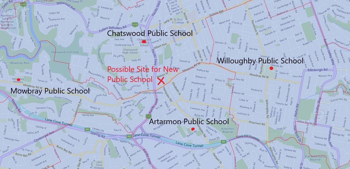
Currently, it is speculated that the new public school will be sited at dive site for Sydney Metro located at the corner of Pacific high way and Mowbray road. You can look at the 2021 catchment map and see the proposed site marked by X.
Looking at the site, this likely means further reduction of the catchment of the existing Chatswood Public School catchment, possibly extend to Mowbray, Artarmon, and nearby Willoughby Public School as well. These three schools all received recent upgrades, so they are probably not under immediate heavy enrolment pressure. I would guess most of the catchment of this new school will come from the existing Chatswood Public School’s catchment.
However, this will imply very significant changes to the catchment when the new school is established. Given the current timeline, it will be a few more years at least.
First I want to clarify, this set of map is based on 2019 data released in 2020 which is the most recent one. NAPLAN was canceled in 2020, so there is no data release in 2021, we will have to wait until 2022 for the next set of data releases.
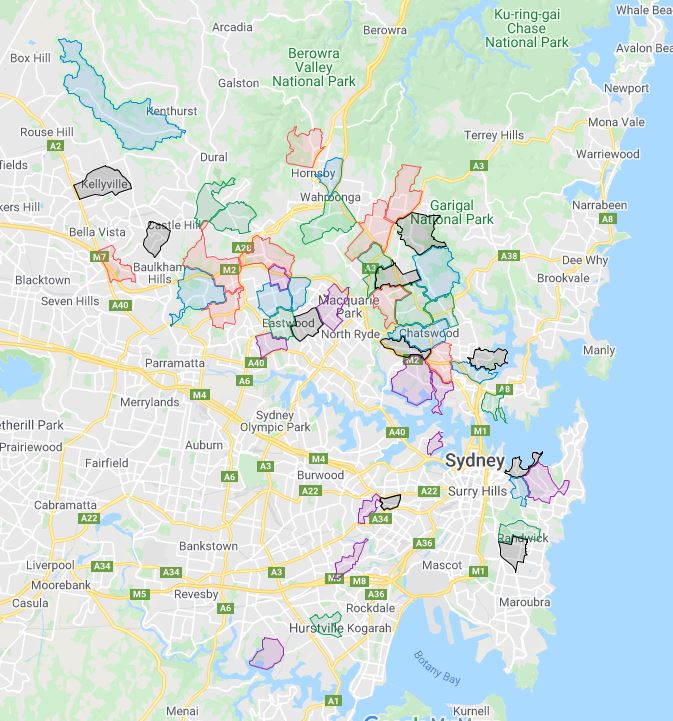
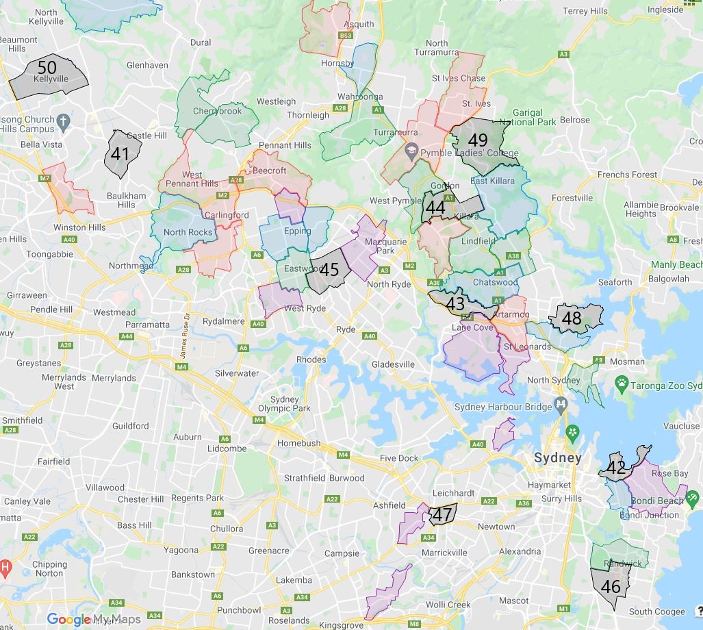
49 out of 50 top NSW primary schools are concentrated in Sydney, with only one exception that is Charlestown South Public School in Newcastle.
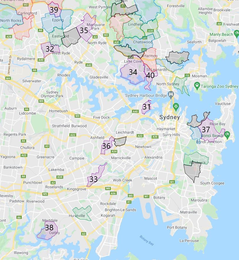
Following is where all the top 50 NSW, Sydney primary schools, as you can see as expected they are mainly concentrated to Sydney’s northwest and north shore area with a splash in eastern and inner west suburbs.
The top 10 for 2019 are all in Sydney’s northwest and lower north shore with the exception of Sydney Distance Education Primary School who will be moving into the site of Lindfield Learning Village from next year, so I guess we can just pretend it is part of North Shore as well. Please note the top 10 are highlighted in red.
Matthew Pearce Public School
St Ives North Public School
Hornsby North Public School
Sydney Distance Education Primary School
Artarmon Public school
Beaumont Road Public School
Murray Farm Public School
Pymble Public School
Beecroft Public School
Carlingford West Public School
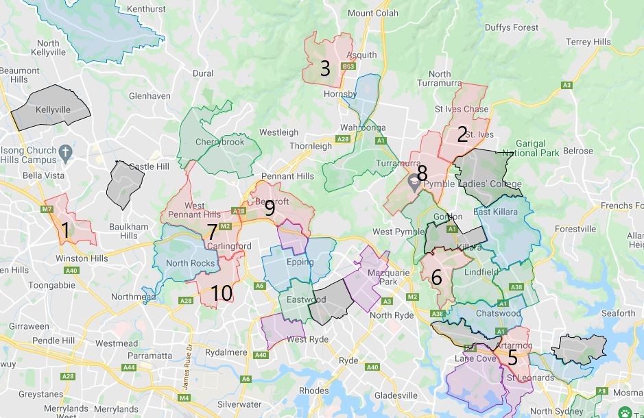
The top 11 to 20 for 2019 are mostly in Sydney’s northwest and lower north shore as well with the exception of Charlestown South Public School in Newcastle. Please note the top 11 to 20 are highlighted in blue.
Cammeray Public School
Annangrove Public School
Woollahra Public School
Waitara Public School
Epping Public School
North Rocks Public School
Epping West Public School
Lindfield East Public School
Charlestown South Public School
Chatswood Public School
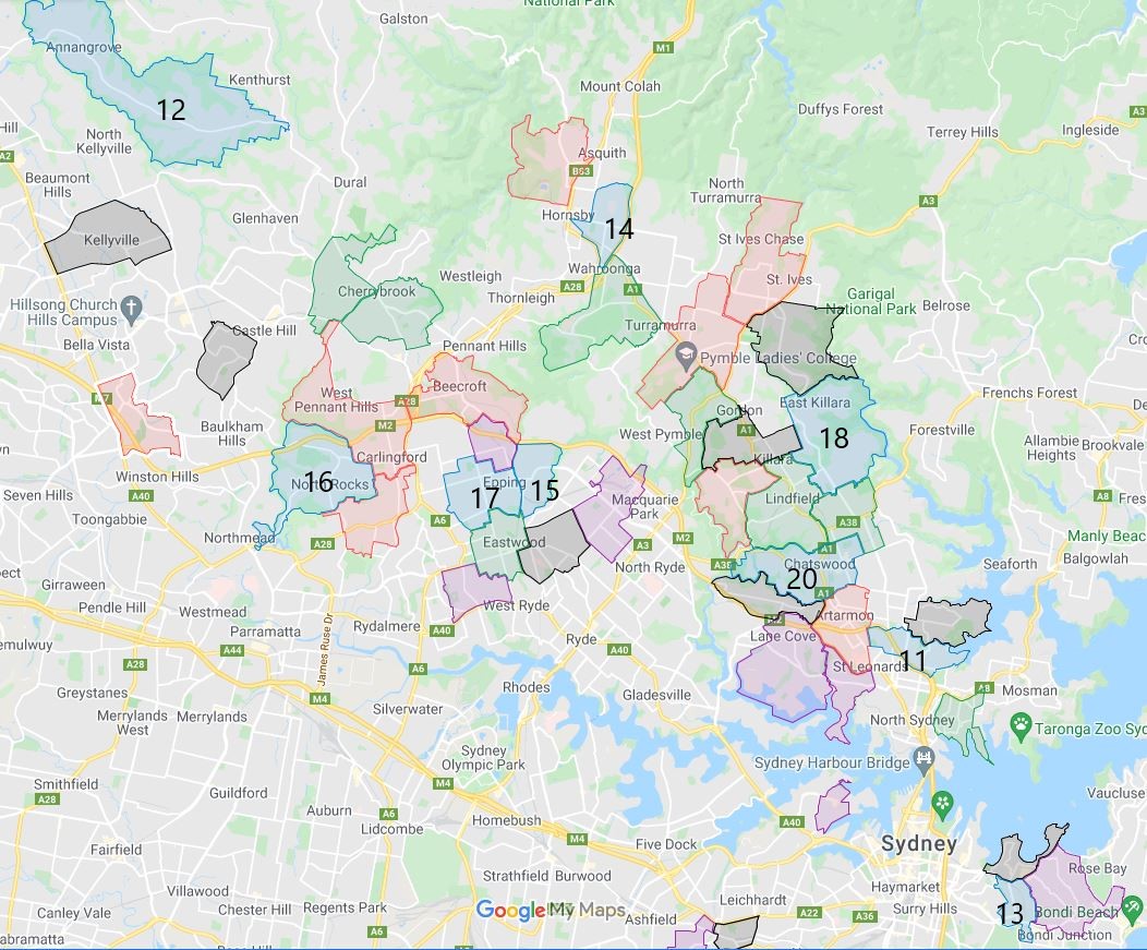
The top 21 to 30 for 2019 are mostly in Sydney’s northwest and lower north shore again, but we start to see two schools Hurstville and Randwick Public School in this range in Sydney’s east and south. Please note the top 21 to 30 are highlighted in green.
Eastwood Public School
Hurstville Public School
Cherrybrook Public School
Warrawee Public School
Lindfield Public School
Roseville Public School
Neutral Bay Public School
Oakhill Drive Public School
Randwick Public School
Gordon West Public School
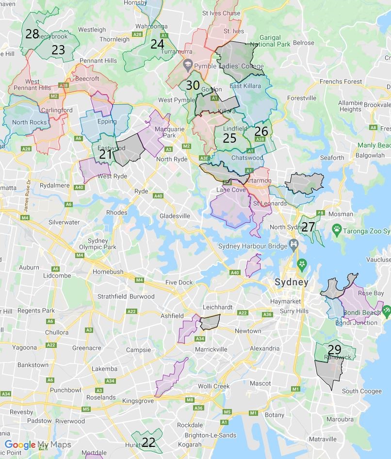
The top 31 to 40 for 2019 are more evenly spread out and evenly split into the different sides of Sydney harbor. Please note the top 31 to 40 are highlighted in purple.
Balmain Public School
Ermington Public School
Earlwood Public School
Lane Cove Public School
Kent Road Public School
Summer Hill Public School
Bellevue Hill Public School
Oatley West Public School
Epping Heights Public School
Greenwich Public School
The top 41 to 50 for 2019 are more concentrated to the north of the Sydney harbor again with a splash in Sydney’s east and inner west again. Please note the top 41 to 50 are highlighted in black.
Excelsior Public School
Double Bay Public School
Mowbray Public School
Killara Public School
Denistone East Public School
Rainbow Street Public School
Petersham Public School
Northbridge Public School
St Ives Public School
Kellyville Public School
The top NSW, Sydney public school are concentrated in the northwest, north and north shore area of Sydney. This is to be expected and continued the trend when I started doing this from 2015. There are actually more schools located in the Sydney’s east and inner west suburb now, this is very good to see.
Stage 2 of Lindfield Learning Village is currently in progress with the aim of delivering the following.
Refurbishment of the existing buildings.
Internal fitout works, delivered in phases.
New kiss and drop and bus access.
New covered outdoor learning area (COLA) and additional play space.
Repurposing the existing lecture theatres into new drama and music teaching theatres.
Relocation of Aurora College (NSW Department of Education’s Selective Virtual High School) to Lindfield Learning Village.
This is scheduled to finish and ready for 2022, just in time for the newly defined school catchment to come into effect.
The most common name used by the NSW Department of Education is called “catchment” which refers to those students who reside in a particular area are guaranteed a position in specific schools. When discussed from the perspective of a particular school is often referred to as one of the following terms.
School Zone
School intake area
School catchment
As usual contact the school in question or the Department of Education for the final confirmation.
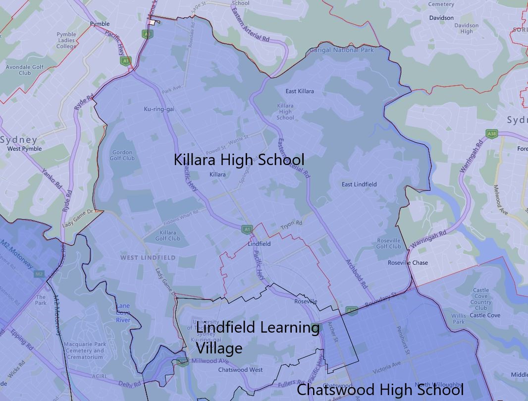
Killara High School catchment actually will expand fairly significantly in 2022. The area around the Lindfield railway station that is currently part of Chatswood High School catchment will be transferred to Killara High School.
This area actually got a lot of medium to high-density buildings, so the population density is pretty high. I am actually a little surprised this particular transfer happened due to the historical enrolment pressure on the Killara High School.
I did visit Killara High School a couple of times in the last few years, it has pretty good facilities for public school standard. All the ones I have seen and being inside are fairly modern and in good condition. I only saw a couple of demountable classrooms which are a pretty common sight in many other NSW schools.
Please note the red-striped areas are what will be transferred away from Chatswood High School to Killara High School in 2022. The black border is the 2022 catchment boundary and the red is the 2021 boundary.
2022 Killara High School Catchment Map
The most common name used by the NSW Department of Education is called “catchment” which refers to those students who reside in a particular area who are guaranteed a position in specific schools. When discussed from the perspective of a particular school is often referred to as one of the following terms.
School Zone
School intake area
School catchment
As usual contact the school in question or the Department of Education for the final confirmation and you can also access the full NSW and Sydney High School Catchment Map by following this link.
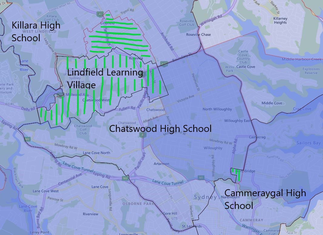
Chatswood High School same as Chatswood Public School is the focus of the changes due to the official release of the Lindfield Learning Village catchment for 2022.
The northern tip of the existing Chatswood High School catchment will be transferred to Killara High School in 2022.
The rest of the northern section of the existing Chatswood High School catchment will be transferred to Lindfield Learning Village in 2022 as well.
A very tiny catchment area that is sandwiched between Sailors Bay Road and Flat Rock Drive of existing Chatswood High School will be transferred to Cammeraygal High School in 2022.
Please note the green-striped areas are what will be transferred away from Chatswood High School to other nearby high schools in 2022. The black border is the 2022 catchment boundary and the red is the 2021 boundary.
2022 Chatswood High School Catchment Map
The most common name used by the NSW Department of Education is called “catchment” which refers to those students who reside in a particular area who are guaranteed a position in specific schools. When discussed from the perspective of a particular school is often referred to as one of the following terms.
School Zone
School intake area
School catchment
As usual contact the school in question or the Department of Education for the final confirmation and you can also access the full NSW and Sydney High School Catchment Map by following this link.
When I went to the Killara Public School a couple of years back, it was still full of demountable classrooms. It has recently received a much-needed school upgrade. Unfortunately, I had not been back recently to see the completed upgrades.
I actually did not expect the catchment area for Killara Public School to shrink so much for 2022. The entire area of its existing catchment area east of the railway got transferred to Lindfield East Public School.
Another section west of the railway of the existing catchment is transferred from Killara Public School to Lindfield Public School in 2022.
Please note the green-striped areas are what will be transferred away from Killara Public School to other nearby public schools in 2022. The black border is the 2022 catchment boundary and the red is the 2021 boundary.
2022 Killara Public School Catchment Map
The most common name used by the NSW Department of Education is called “catchment” which refer to those students who reside in a particular area is guaranteed a position in specific schools. When discussed from the perspective of a particular school is often referred to as one of the following terms.
School Zone
School intake area
School catchment
As usual contact, the school in question or the Department of Education for the final confirmation and you can also access the full NSW and Sydney Public School Catchment Map by following this link.
I was actually a little surprised that Lindfield East Public School’s catchment was expanded in a non-insignificant fashion in 2022. The nearby Killara Public School must be under fairly seriously enrolment number pressure even after the recently received school upgrade.
The current Killara Public School’s catchment east of the railway will be transferred to Lindfield East Public School in 2022.
Lindfield Public School’s current catchment’s eastern edge will also be transferred to Lindfield East Public School in 2022.
As previously mentioned in the previous update, Roseville Public School will receive the southern edge of the current Lindfield East Public School in 2022.
Please note the red-striped areas are what will be transferred to Lindfield East Public School in 2022, green striped areas are what will be transferred away to other nearby public schools in 2022. The black border is the 2022 catchment boundary and the red is the 2021 boundary.
2022 Lindfield East Public School Catchment Map
The most common name used by the NSW Department of Education is called “catchment” which refer to those students who reside in a particular area is guaranteed a position in specific schools. When discussed from the perspective of a particular school is often referred to as one of the following terms.
School Zone
School intake area
School catchment
As usual contact, the school in question or the Department of Education for the final confirmation and you can also access the full NSW and Sydney Public School Catchment Map by following this link.
In this round of changes, Lindfield Public School is the one that had the most significant changes to its catchment. It was previously very crowded and these changes are sorely needed.
The entire southern section of the Lindfield Public School catchment will be transferred to Lindfield Learning village in 2022.
A very small section of the northwestern corner of the existing Roseville Public School’s catchment will be transferred to Lindfield Public School in 2022.
Lindfield East Public School will take over a fair bit of the eastern segment of the catchment from Lindfield Public School in 2022.
Lindfield Public School will also take over the southeast corner of what use to the catchment of the Killara Public School in 2022 as well.
Please note the red-striped areas are what will be transferred to Lindfield Public School in 2022, green striped areas are what will be transferred away to other nearby public schools in 2022. The black border is the 2022 catchment boundary and the red is the 2021 boundary.
2022 Lindfield Public School Catchment Map
The most common name used by the NSW Department of Education is called “catchment” which refer to those students who reside in a particular area is guaranteed a position in specific schools. When discussed from the perspective of a particular school is often referred to as one of the following terms.
School Zone
School intake area
School catchment
As usual contact, the school in question or the Department of Education for the final confirmation and you can also access the full NSW and Sydney Public School Catchment Map by following this link.
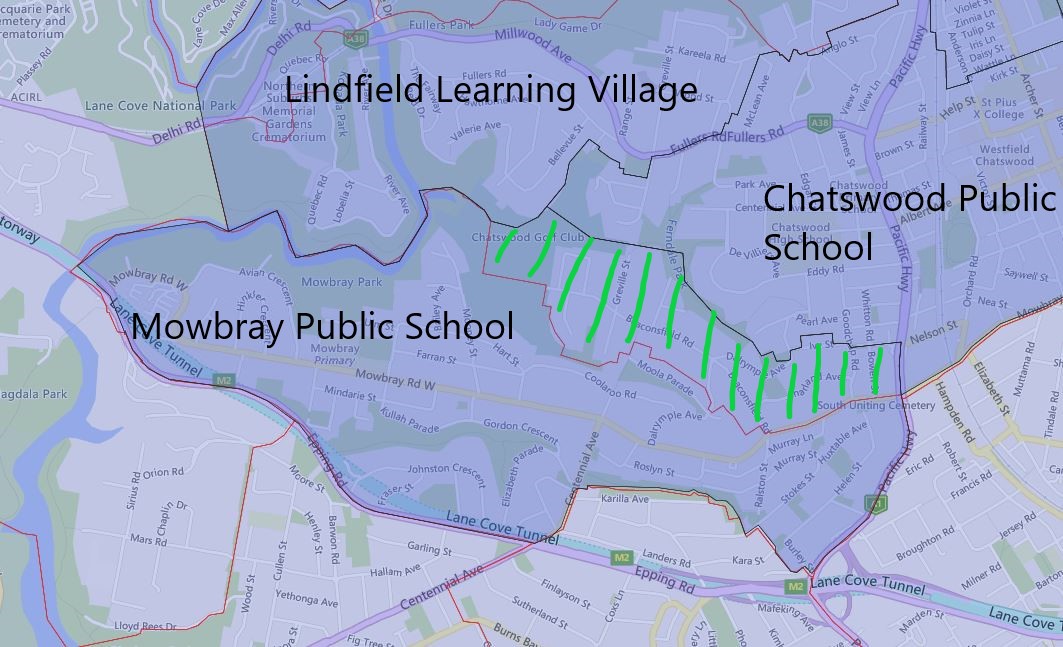
The expansion and upgrade of Mowbray Public School were completed a couple of years ago. All the old demountable classrooms got removed and replaced with a very large brand new multi-story building. I previously speculated possible changes to the catchment and what is coming in 2022 closely matched that.
Basically, the southern edges of what was previously part of Chatswood Public School got transferred to Mowbray Public School in 2022.
2022 Mowbray Public School Catchment Map
The most common name used by the NSW Department of Education is called “catchment” which refer to those students who reside in a particular area is guaranteed a position in specific schools. When discussed from the perspective of a particular school is often referred to as one of the following terms.
School Zone
School intake area
School catchment
As usual contact, the school in question or the Department of Education for the final confirmation and you can also access the full NSW and Sydney Public School Catchment Map by following this link.
 Email This Post