Mowbray Public School

I have not done a specific school introduction for a while, mostly due to I have not had the chance to collect the information needed. Starting this back up with Mowbray Public School which I manage to find some time to visit on last Sunday. I could not find information on when the Mowbray Public School was established and there seem to be distinctive lack of general information on this school via online searching. This rather unfortunately as I was hoping to get some background information on the school.

Mowbray Public School is located on the Mowbray Road in the suburb of Lane Cove North. North of the Mowbray road belongs to Willoughby council and south of the road is part of the Lane Cove Council. Lane Cove Council recently rezoned pretty much entire section alone the Mowbray road and apartments just spring up like weeds in my garden after a good summer rain. I drove past this section of the road almost weekly and in the space of a few years, the entire southern side of Mowbray road in Lane Cove West is either built, being built or waiting to be built. This, of course, is one of the reasons that Mowbray Public school is undergoing a major expansion.

In 2014 there were 378 students enrolled and compare to 2008’s number of 267 students, this is an increase of 42% over the space of six years. This might sound high, but actually not uncommon in North Shore area. In 2014, 36 per cent of the students in the school are from none English language background. This number actually is fairly consistent over the years, fluctuating between 35 to 41 per cent. This number may rise in the next few years, with a lot of Asian buying in the area in the recent time, a fair number gets pushed over into Mowbray Public School’s catchment due to sky-high property price in Chatswood.

Mowbray Public School does very well academically and consistently ranked as one of the state’s top public school.

20102011201220132014
Ranking91212619372

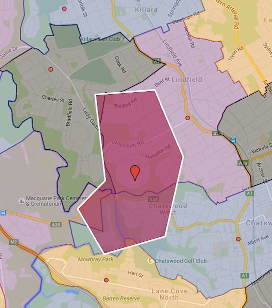
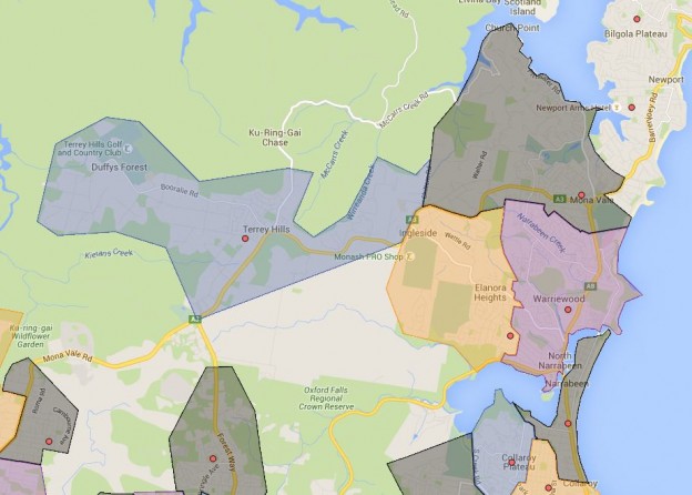
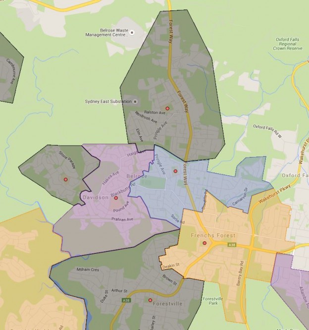
Mowbray Public School Catchment is bounded by Epping road to the south, Pacific High Way to the east, Chatswood golf club, Coolaroo Park to the north and Lane Cove River to the west. A really major expansion for the school is currently underway and proposed to be finished by 2016. The enrolment number is estimated to triple from 360 to 1000. What this means is that it will likely absorb part of the catchment of nearby schools that are currently overcrowded and under stress. Following is the current catchment map, once the new expansion completes, this will probably expand significantly. I will do another post to guess the possible changes in the catchment this will result in. You can search for a particular school or address in the search box in the top right-hand corner of the embedded map or zoom into an area of interest on the map.

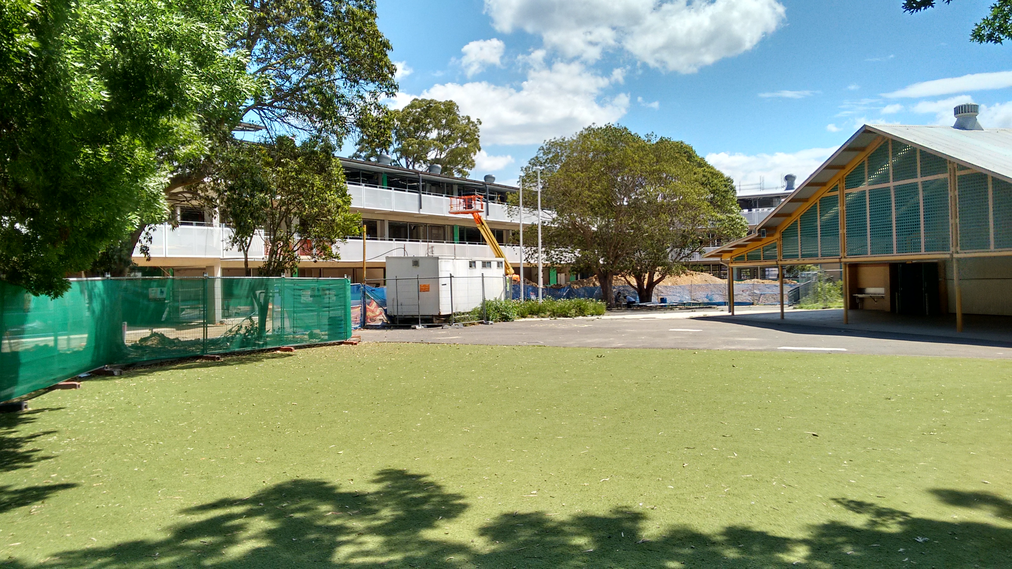
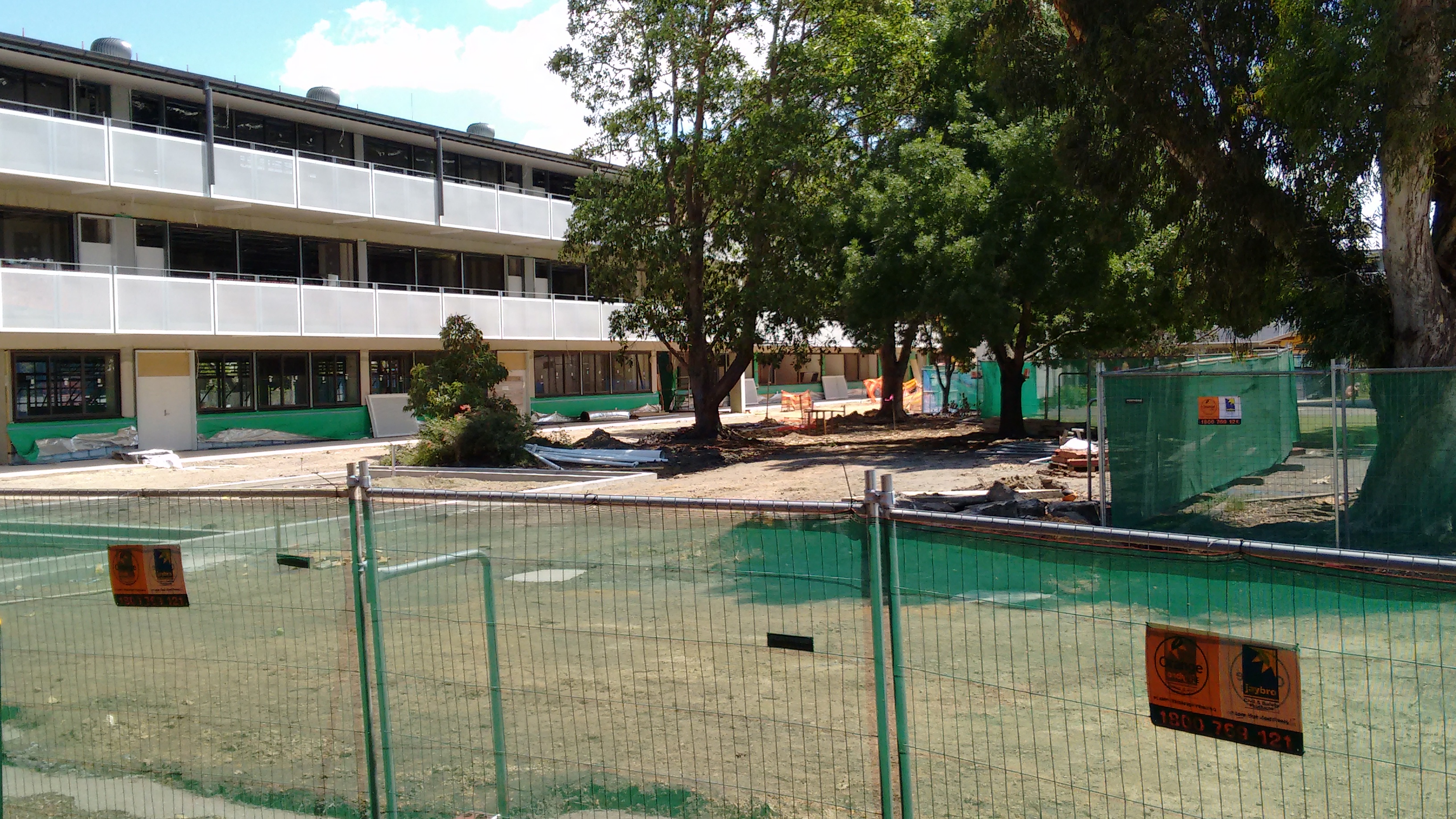
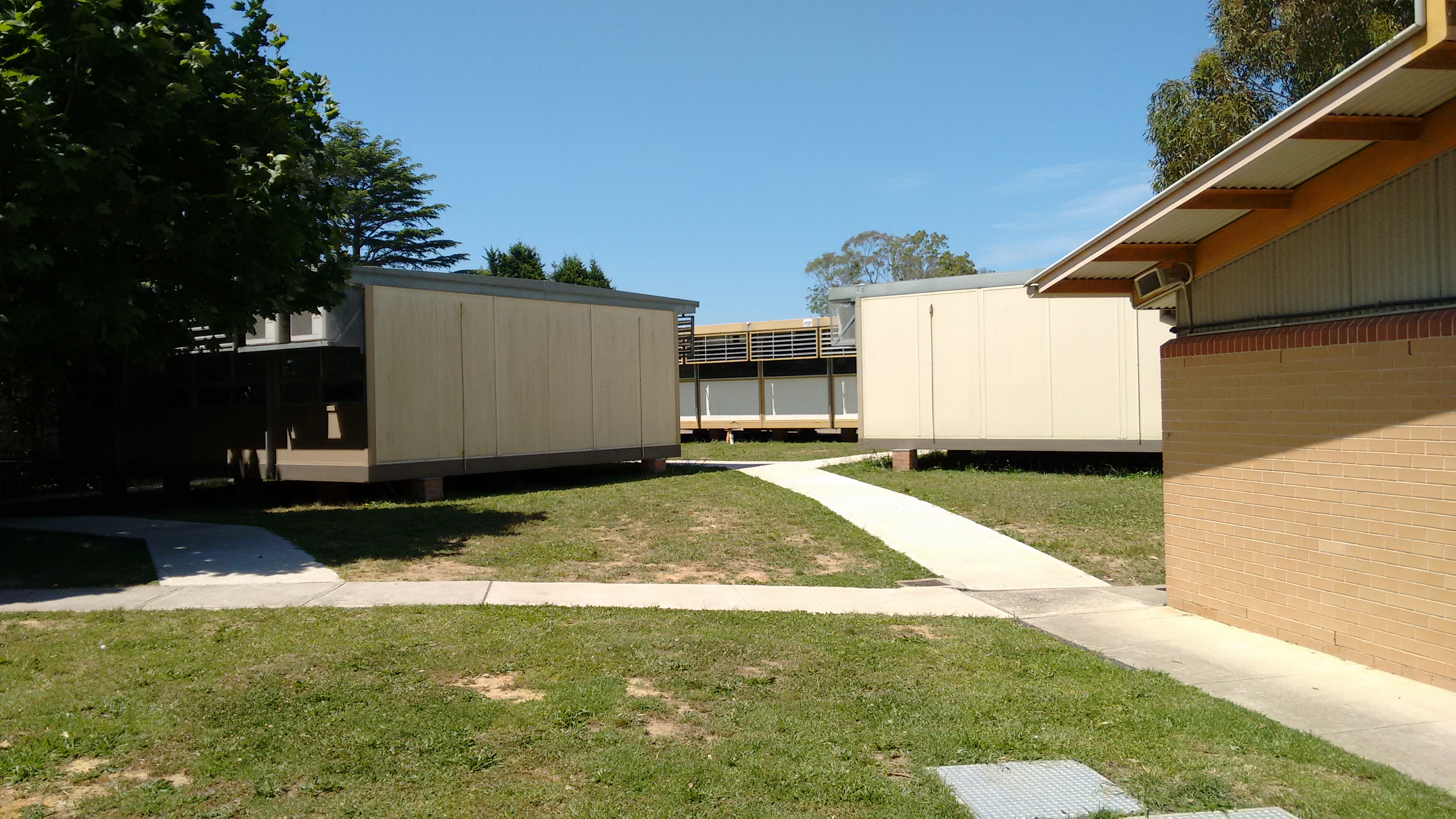
The catchment use to be a good mix of multi and single dwellings, however recently following Lane Cove council’s rezoning, apartments are going up in a maddening fashion alone the Mowbray Road. This no doubt contributes to the need to expand the school’s capacity as it will no longer able to deal with the significant increase in population. I drove pass Mowbray Road weekly and it was really interesting to see the progress of the new classrooms close up last weekend. I took a few pictures and it is certainly a massive expansion and definitely the biggest of all the schools I have visited so far. In the following Google Map cut out, I draw out roughly what the new building situates compare to the old set up. The bottom area as marked on the map alone the Mowbray Road is where the new building is going up, essentially all the old classrooms got demolished to make room for it. About 20 new demountables are placed in the northern part of the school as marked on the map. Expect these to be removed once the new classrooms are completed and ready for use.

Mowbray Public School Pre Expansion Satellite Map With Marking

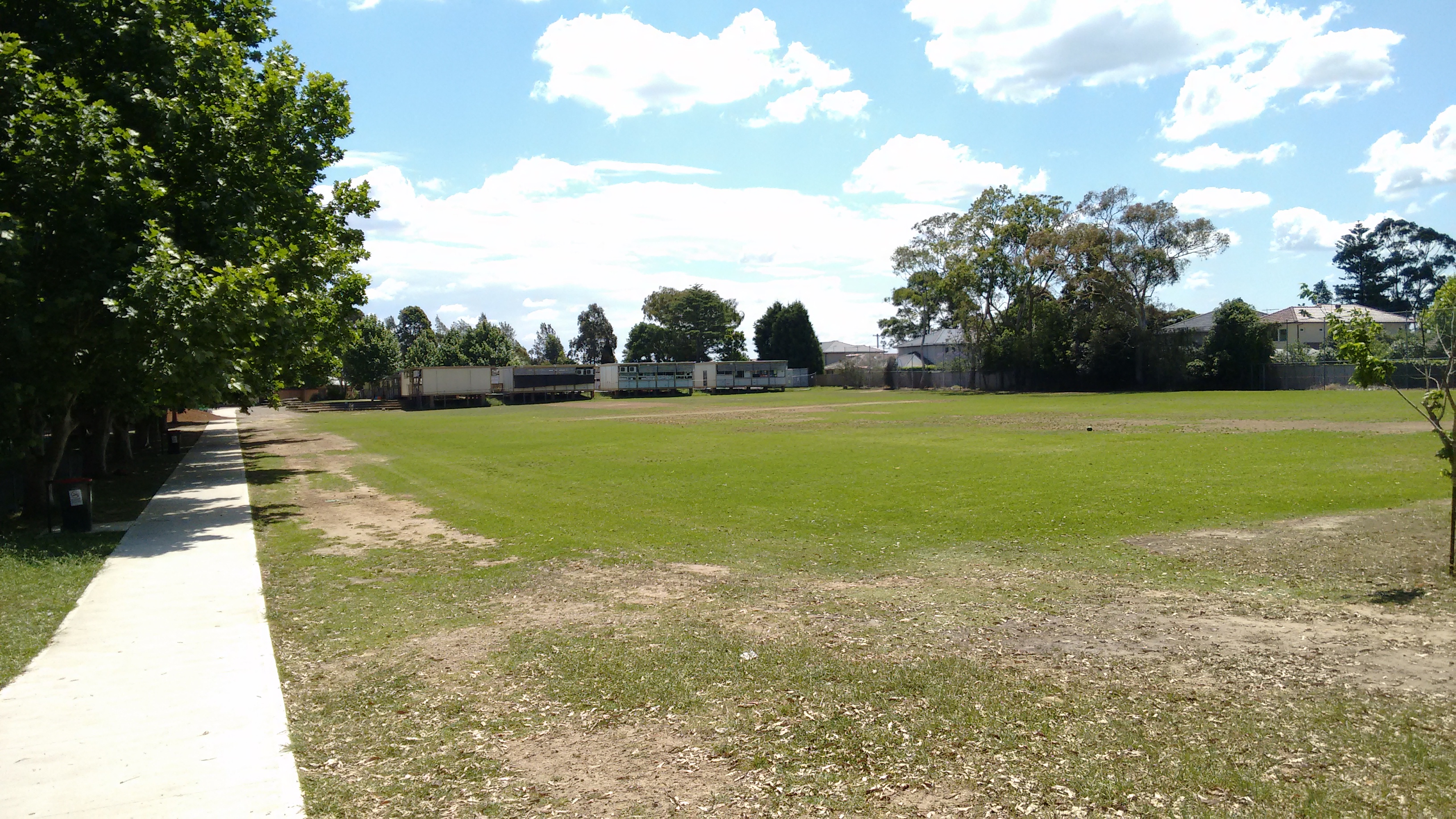
I quite like the new design, it pretty much maintained all the open space and oval. Public school often utilized for a variety of activities outside of school hours and maintaining these open spaces are very important inside and outside of school hours. The new classrooms look great and I am looking forward to its completion and students moving out of demountables. Due to the mounting pressure with the increase in enrolment, it is rare in North Shore area to maintain such lovely amount of open space which will be great for the community in the long run.

Following is the new classrooms that are under construction.

IMG_20151101_134912261_HDR IMG_20151101_134829846

Following is the lovely existing oval view of demountables are currently up to replace the existing classrooms while the new classrooms are under construction.

IMG_20151101_135103961 IMG_20151101_134620198

As usual contact the school in question or Department of Education for the final confirmation and you can also access the full NSW and Sydney Public School Catchment Map by following this link.

Share this post:

Email This Post Email This Post

Crawford, Doonside, Marayong and Marayong South Public School Catchment Map Added

Back to the bread and butter of what I do, four more school added for the Western Sydney. I have not decided which direction to go after this batch, whether keep heading west and or going to try to fill out the south west instead. With the this batch, I am not super happy about the catchment for Marayong Public School, part of it may very well belong to the Black North Public School instead, so I will revisit this again in the future.

  • Crawford Public School
  • Doonside Public School
  • Marayong Public School
  • Marayong South Public School

As usual contact the school in question or Department of Education for the final confirmation and you can also access the full NSW and Sydney Public School Catchment Map by following this link.

Share this post:

Major delays in opening of new public schools in west Lindfield from 2017 to 2019

I just read the news that new public schools in west Lindfield on the old UTS Kuring-gai site is not expected to open until at least 2019, this is changed from original schedule of 2017, original article Overcrowded Sydney schools will wait longer for new space on SMH. The news has major implication for the North Shore area, this is the first major new school opening in a long time and urgently required to relief the strain a lot of public school in the area went through in the last few years. Some schools went through 40 to 50 percent increase in the number of students enrolled in just handful of years, Chatswood public school is probably one of the worst hit and with huge influx of new apartments being completed in next year or two in the area, this is going to get worse. Surrounding public schools all have similar issue and have very limited spare capacity to absorb the new influx.

Now is a bit of fun exercise on what potentially the school catchment of new Lindfield West Public School can look like in 2019 when it opens.

Lindfield West Public School Catchment Map

Most of potential catchment for the new Lindfield West Public School will likely coming out of Lindfield Public School which is very crowded and reducing its burden will allow it to cater for the increased apartments in its catchment and take over some of the load for its neighbouring schools as well. Also the most over crowded the school near by is Chatswood Public School, so I think there is a high chance that Chatswood West will ended up in the catchment of the Lindfield West Public School when it opens. Currently Chatswood West is far enough from Chatswood Public School, it not likely making that much difference shifting it to the new school. There is minor possibilities of part of the Beaumont Road Public School catchment gets shifted to the new Lindfield West, but its zone are well isolated and do not have a large number multi dwelling being completed, so its enrolment number is not likely to change significantly in the near future anyway. I do not see large change of its catchment when the new school opens.

So after 2019, I can see large part of Chatswood and Lindfield Public School’s catchment going to the new school. As a consequence, it is likely that surrounding schools will see changes to their catchment as well, such as Roseville and Killara Public School etc. Overall this is going to be interesting time and I cannot wait to see new investment in the public education to bear fruit and the opening of the new schools.

As usual contact the school in question or Department of Education for the final confirmation and you can also access the full NSW and Sydney Public School Catchment Map by following this link.

Share this post:


Bert Oldfield, Blacktown South, Blacktown West, Shelley and Walters Road Public School Catchment Maps Added

Five more added for the Western Sydney, population of western Sydney has exploded over last few decades. This is likely to keep going, also the transport hubs near the train lines such as Blacktown will likely see a lot more medium to high density area come into play. What these will do are either new schools gets constructed or existing ones expanding. Looking at the maps, the public schools all look to be somewhat larger than their eastern counter parts which means there is room for expansion if so required.

  • Bert Oldfield Public School
  • Blacktown South Public School
  • Blacktown West Public School
  • Shelley Public School
  • Walters Road Public School

As usual contact the school in question or Department of Education for the final confirmation and you can also access the full NSW and Sydney Public School Catchment Map by following this link.

Share this post:

Berowa, Brooklyn, Cowan, Mount Colah, Mount Kuring-Gai and Wideview Public School Catchment Map Added

Added the northern tip of the Sydney and there is a lot of interesting bits where there is no access other than ferry or private boats. I might do a post on some of the interesting bits just for the fun of it in the future. With the catchment for Brooklyn Public School, I just went with my fancy and drawn what is seem to be most logical to be included. Alright enough of my nerd talk and here it goes

  • Berowa Public School
  • Brooklyn Public School
  • Cowan Public School
  • Mount Colah Public School
  • Mount Kuring-Gai Public School
  • Wideview Public School

As usual contact the school in question or Department of Education for the final confirmation and you can also access the full NSW and Sydney Public School Catchment Map by following this link.

Share this post:

Blacktown North, Marayong Heights and Quakers Hill Public School Catchment Map Added

A smaller update than usual, just too much personal and work stuff happening right now. I do not know how long this sort of crazy times will keep going, but will try to at least keep up with regular updates. Three more public school catchment added for Western Sydney.

  • Blacktown North Public School
  • Marayong Heights Public School
  • Quakers Hill Public School

As usual contact the school in question or Department of Education for the final confirmation and you can also access the full NSW and Sydney Public School Catchment Map by following this link.

Share this post:

Avalon, Bilgola Plateau and New Port Public School Catchment Map Added

Only three public school catchment map added, however this marks the completion of the Northern Beaches area for Sydney. There is really only Western and South Western Sydney left to do.

  • Avalon Public School
  • Bilgola Plateau Public School
  • New Port Public School

As usual contact the school in question or Department of Education for the final confirmation and you can also access the full NSW and Sydney Public School Catchment Map by following this link.

Share this post:

Elanora Heights, Narrabeen Lakes, Narrabeen North, Mona Vale and Terry Hills Public School Catchment Map Added

Back from a short holiday over the long weekend, wish it was longer. However it was nice to be back in the saddle and get back to updating the map again. Getting close to closing out the North Beaches area. Five more public school catchment added as following

  • Elanora Heights Public School
  • Narrabeen Lakes Public School
  • Narrabeen North Public School
  • Mona Vale Public School
  • Terry Hills Public School

As usual contact the school in question or Department of Education for the final confirmation and you can also access the full NSW and Sydney Public School Catchment Map by following this link.

Share this post:

Beacon Hill, Collaroy Plateau, Cromer, Dee Why and Wheeler Heights Public School Catchment Map Added

Five more public school catchment for the beautiful Sydney north shore area added. There is probably one or two more update worth of the work to do for North Shore, should be done soon and I’ll move back to Western Sydney most likely afterwards.

  • Beacon Hill Public School
  • Collaroy Plateau Public School
  • Cromer Public School
  • Dee Why Public School
  • Wheeler Heights Public School

As usual contact the school in question or Department of Education for the final confirmation and you can also access the full NSW and Sydney Public School Catchment Map by following this link.

Share this post:

Belrose, French Forest, Kambora, Mimosa and Wakehurst Public School Catchment Maps Added

It is time to get back to Northern Beaches, five more catchment map for public schools added. I will most likely aim to finish the entire Northern Beaches before moving on to another area in Sydney.

  • Belrose Public School
  • French Forest Public School
  • Kambora Public School
  • Mimosa Public School
  • Wakehurst Public School

As usual contact the school in question or Department of Education for the final confirmation and you can also access the full NSW and Sydney Public School Catchment Map by following this link.

Share this post:

en_AUEnglish (Australia)