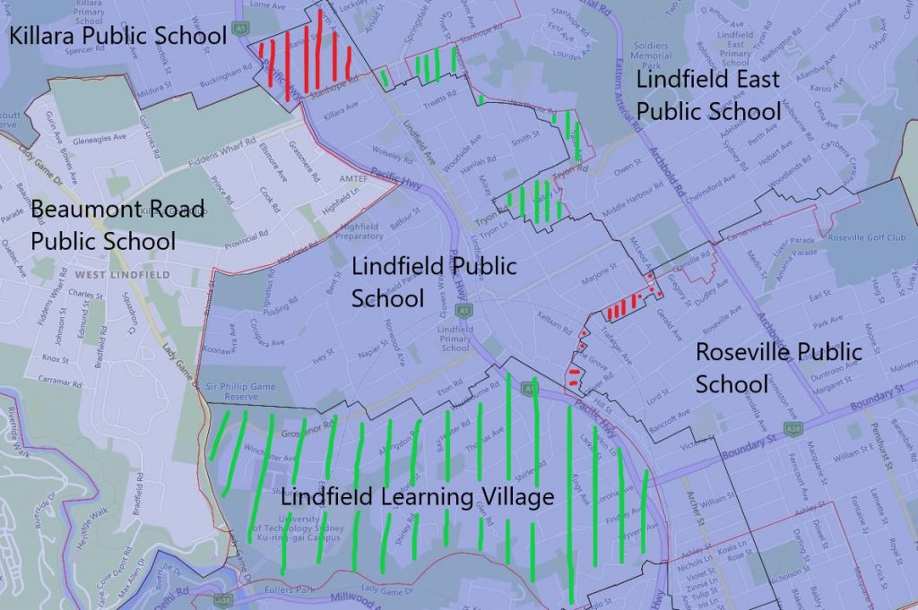
In this round of changes, Lindfield Public School is the one that had the most significant changes to its catchment. It was previously very crowded and these changes are sorely needed.
The entire southern section of the Lindfield Public School catchment will be transferred to Lindfield Learning village in 2022.
A very small section of the northwestern corner of the existing Roseville Public School’s catchment will be transferred to Lindfield Public School in 2022.
Lindfield East Public School will take over a fair bit of the eastern segment of the catchment from Lindfield Public School in 2022.
Lindfield Public School will also take over the southeast corner of what use to the catchment of the Killara Public School in 2022 as well.
Please note the red-striped areas are what will be transferred to Lindfield Public School in 2022, green striped areas are what will be transferred away to other nearby public schools in 2022. The black border is the 2022 catchment boundary and the red is the 2021 boundary.
2022 Lindfield Public School Catchment Map

The most common name used by the NSW Department of Education is called “catchment” which refer to those students who reside in a particular area is guaranteed a position in specific schools. When discussed from the perspective of a particular school is often referred to as one of the following terms.
- School Zone
- School intake area
- School catchment
As usual contact, the school in question or the Department of Education for the final confirmation and you can also access the full NSW and Sydney Public School Catchment Map 通过点击此链接。
分享这个帖子:
 通过电子邮件分享此帖