Colonel Light Gardens Primary School

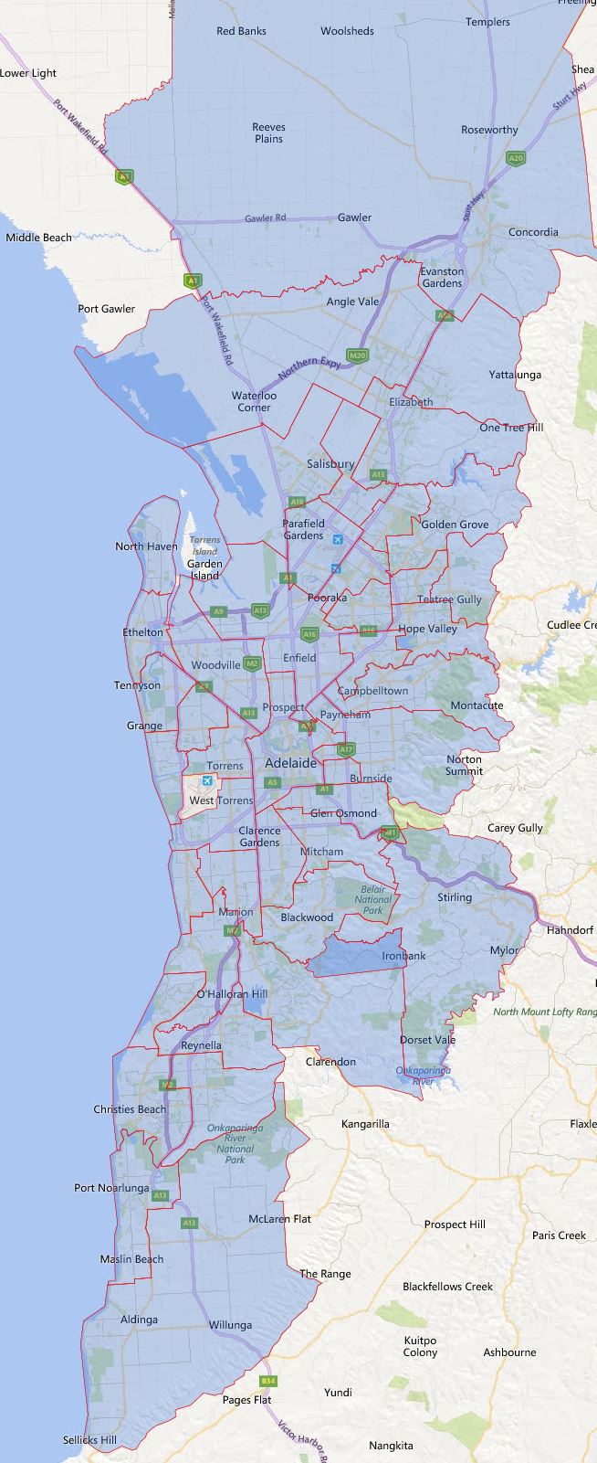
This is the school zone map for Colonel Light Gardens Primary School in South Australia. You can search for a particular school or address in the search box in the top right-hand corner of the embedded map or zoom into an area of interest on the map.

Please note there are a number of different ways the term school zone is referred, they can be also called school catchment, intake areas etc. Some of the schools have defined school zone, while the others are based on the closest distance between the student’s resident to the nearest school.

For the final confirmation please contact the school in question and you can find the Full South Australian Primary School Zone Map by following this link.

Share this post:

Email This Post Email This Post

Burton Primary School

This is the school zone map for Burton Primary School in South Australia. You can search for a particular school or address in the search box in the top right-hand corner of the embedded map or zoom into an area of interest on the map.

Please note there are a number of different ways the term school zone is referred, they can be also called school catchment, intake areas etc. Some of the schools have defined school zone, while the others are based on the closest distance between the student’s resident to the nearest school.

For the final confirmation please contact the school in question and you can find the Full South Australian Primary School Zone Map by following this link.

Share this post:

Email This Post Email This Post

Burn Side Primary School

This is the school zone map for Burn Side Primary School in South Australia. You can search for a particular school or address in the search box in the top right-hand corner of the embedded map or zoom into an area of interest on the map.

Please note there are a number of different ways the term school zone is referred, they can be also called school catchment, intake areas etc. Some of the schools have defined school zone, while the others are based on the closest distance between the student’s resident to the nearest school.

For the final confirmation please contact the school in question and you can find the Full South Australian Primary School Zone Map by following this link.

Share this post:

Email This Post Email This Post

Brighton Primary School (South Australia)

This is the school zone map for Brighton Primary School (South Australia) in South Australia. You can search for a particular school or address in the search box in the top right-hand corner of the embedded map or zoom into an area of interest on the map.

Please note there are a number of different ways the term school zone is referred, they can be also called school catchment, intake areas etc. Some of the schools have defined school zone, while the others are based on the closest distance between the student’s resident to the nearest school.

For the final confirmation please contact the school in question and you can find the Full South Australian Primary School Zone Map by following this link.

Share this post:

Email This Post Email This Post

Blakeview Primary School

This is the school zone map for Blakeview Primary School in South Australia. You can search for a particular school or address in the search box in the top right-hand corner of the embedded map or zoom into an area of interest on the map.

Please note there are a number of different ways the term school zone is referred, they can be also called school catchment, intake areas etc. Some of the schools have defined school zone, while the others are based on the closest distance between the student’s resident to the nearest school.

For the final confirmation please contact the school in question and you can find the Full South Australian Primary School Zone Map by following this link.

Share this post:

Email This Post Email This Post

Black Forest Primary School

This is the school zone map for Black Forest Primary School in South Australia. You can search for a particular school or address in the search box in the top right-hand corner of the embedded map or zoom into an area of interest on the map.

Please note there are a number of different ways the term school zone is referred, they can be also called school catchment, intake areas etc. Some of the schools have defined school zone, while the others are based on the closest distance between the student’s resident to the nearest school.

For the final confirmation please contact the school in question and you can find the Full South Australian Primary School Zone Map by following this link.

Share this post:

Email This Post Email This Post

Ardtornish Primary School

This is the school zone map for Ardtornish Primary School in South Australia. You can search for a particular school or address in the search box in the top right-hand corner of the embedded map or zoom into an area of interest on the map.

Please note there are a number of different ways the term school zone is referred, they can be also called school catchment, intake areas etc. Some of the schools have defined school zone, while the others are based on the closest distance between the student’s resident to the nearest school.

For the final confirmation please contact the school in question and you can find the Full South Australian Primary School Zone Map by following this link.

Share this post:

Email This Post Email This Post

Angle Vale Primary School

This is the school zone map for Angle Vale Primary School in South Australia. You can search for a particular school or address in the search box in the top right-hand corner of the embedded map or zoom into an area of interest on the map.

Please note there are a number of different ways the term school zone is referred, they can be also called school catchment, intake areas etc. Some of the schools have defined school zone, while the others are based on the closest distance between the student’s resident to the nearest school.

For the final confirmation please contact the school in question and you can find the Full South Australian Primary School Zone Map by following this link.

Share this post:

Email This Post Email This Post

Allenby Gardens Primary School

This is the school zone map for Allenby Gardens Primary School in South Australia. You can search for a particular school or address in the search box in the top right-hand corner of the embedded map or zoom into an area of interest on the map.

Please note there are a number of different ways the term school zone is referred, they can be also called school catchment, intake areas etc. Some of the schools have defined school zone, while the others are based on the closest distance between the student’s resident to the nearest school.

For the final confirmation please contact the school in question and you can find the Full South Australian Primary School Zone Map by following this link.

Share this post:

Email This Post Email This Post

South Australia High School Catchment Zone Map

I had a brief going over of South Australia’s high school catchment map recently.  Look like the entire Adelaide city is covered with specific zoning at secondary school level. So I have created the maps based on the information available on South Australia Department for Education and Child Development.

2017 South Australia Adelaide High School Zoning

The actual map

For final confirmation on school zoning please contact the school in question.

Share this post:

en_AUEnglish (Australia)