2022 Homebush Public School Catchment Update

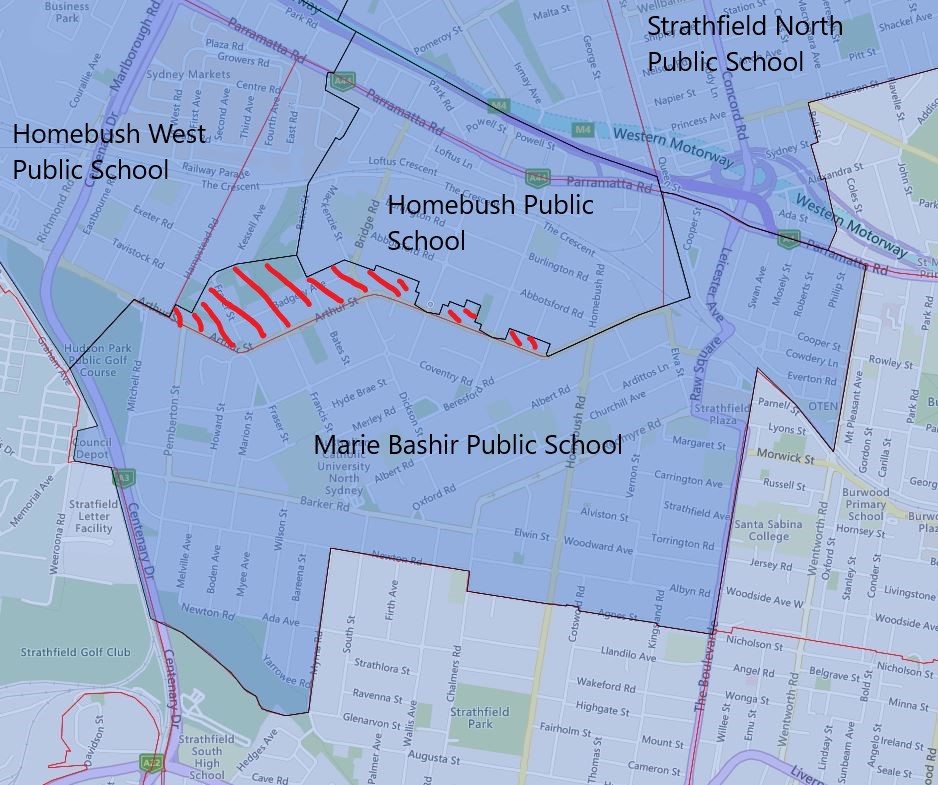
Very significant changes are happening to the catchment of Homebush Public School in 2022. Given the huge amount of large apartments that were built in recent years, it is not a real surprise to see this set of catchment changes. Homebush is not the same suburb that I use to frequent more than twenty years ago, the population density went up massively during the intervening years.

The southern edge of Homebush Public School’s existing catchment will be transferred to Marie Bashir Public School in 2022, this area purely consists of individual houses.

The western edge of its existing catchment will be transferred to Homebush West Public School. This area consists of a mix of medium to low-density dwellings.

It will be adding the area north of the Parramatta Road and south of the motorway to its 2022 catchment. There are a lot of recently built high-density apartment buildings.

Please note the green-striped areas are what will be transferred away from Homebush Public School to Marie Bashir and Homebush West Public School in 2022. The red-striped areas are what will be transferred to the Homebush Public School catchment from Victoria Ave Public School. The black border is the 2022 catchment boundary and the red is the 2021 boundary.

Homebush Public School Catchment Map 2022

The most common name used by the NSW Department of Education is called “catchment” which refers to those students who reside in a particular area who are guaranteed a position in specific schools. When discussed from the perspective of a particular school is often referred to as one of the following terms.

  • School Zone
  • School intake area
  • School catchment

As usual contact the school in question or the Department of Education for the final confirmation and you can also access the full NSW and Sydney Primary School Catchment Map by following this link.

Share this post:

Email This Post Email This Post

2022 Marie Bashir Public School Catchment Update

This is the 2022 updated catchment for Marie Bashir Public School. The changes are relatively minor, it gained a small section north of Arthur Street at the expense of the Homebush Public School.

I had a look at the catchment added in 2022 for Marie Bashir Public School, all the properties look like houses, so this change should not affect the total enrolment that much.

Please note the red-striped areas are what will be transferred to Marie Bashir Public School from Homebush Public School in 2022. The black border is the 2022 catchment boundary and the red is the 2021 boundary.

Marie Bashir Public School 2022 Catchment

The most common name used by the NSW Department of Education is called “catchment” which refers to those students who reside in a particular area who are guaranteed a position in specific schools. When discussed from the perspective of a particular school is often referred to as one of the following terms.

  • School Zone
  • School intake area
  • School catchment

As usual contact the school in question or the Department of Education for the final confirmation and you can also access the full NSW and Sydney Primary School Catchment Map by following this link.

Share this post:

Email This Post Email This Post

New Batch Of 2022 Catchment Update for Sydney Public Schools

I was not expecting so many changes to come out hard and fast. The newly affected public schools are as follows. I will also be detailing the changes to the affected schools one by one in the coming days.

  • Concord West Public School
  • Homebush Public School
  • Homebush West Public School
  • Marie Bashir Public School
  • Mortlake Public School
  • Strathfield North Public School
  • Victoria Ave Public School

The most common name used by the NSW Department of Education is called “catchment” which refers to those students who reside in a particular area who are guaranteed a position in specific schools. When discussed from the perspective of a particular school is often referred to as one of the following terms.

  • School Zone
  • School intake area
  • School catchment

As usual contact the school in question or the Department of Education for the final confirmation and you can also access the full NSW and Sydney Primary School Catchment Map by following this link.

Share this post:

Email This Post Email This Post

2022 Brunswick Heads And Ocean Shores Public School Catchment Update

The area south of the Orana Road is going to be transferred from Brunswick Heads to Ocean Shores Public School in 2022.

Please note the green-striped areas are what will be transferred away from Brunswick Heads Public School to Ocean Shores Public School in 2022. The black border is the 2022 catchment boundary and the red is the 2021 boundary.

The most common name used by the NSW Department of Education is called “catchment” which refers to those students who reside in a particular area who are guaranteed a position in specific schools. When discussed from the perspective of a particular school is often referred to as one of the following terms.

  • School Zone
  • School intake area
  • School catchment

As usual contact the school in question or the Department of Education for the final confirmation and you can also access the full NSW and Sydney Primary School Catchment Map by following this link.

Share this post:

Email This Post Email This Post

2022 Arncliffe Public School Catchment Update

Currently, Arncliffe Public School’s catchment is fairly large by Sydney standard, this is due to it is overlayed with the Kyeemagh Public School which previously is an infant school which only enrol from kindergarten to year four only.

The expansion and renovation of Kyeemagh Public School will be completed this year and it has been updated to a fully-fledged public school catering from all primary year range. As a result of this, Kyeemagh Public School now receiving its dedicated catchment, and Arncliffe Public School’s catchment is greatly reduced as a result of this.

The green-striped area is now a dedicated catchment for Kyeemagh Public School and the red-striped area is exclusively part of Arncliffe Public School’s catchment.

The most common name used by the NSW Department of Education is called “catchment” which refers to those students who reside in a particular area who are guaranteed a position in specific schools. When discussed from the perspective of a particular school is often referred to as one of the following terms.

  • School Zone
  • School intake area
  • School catchment

As usual contact the school in question or the Department of Education for the final confirmation and you can also access the full NSW and Sydney Primary School Catchment Map by following this link.

Share this post:

Email This Post Email This Post

2022 Kyeemagh Public School Catchment Update

Up to now, Kyeemagh Public School is an infant school that is only from kindergarten to year four. The expansion and upgrade of Kyeemagh Public School will be completed by end of this year. It will open its enrolment from kindergarten to year six. It will also no longer share catchment and overlap with the Arncliffe Public School in 2022.

With Kyeemagh Public School becoming a stand-alone public school like the other nearby schools. This basically resulted in pretty significant changes to many surrounding school catchments.

Most of its 2022 catchment is its existing shared one with Arncliffe Public School. In the northeastern corner of Rockdale Public School, about 45 houses are transferred to Kyeemagh Public School as well. Ramsgate Public School gave up a large part of its catchment in the north to Kyeemagh Public School in 2022.

Please note the green-striped areas are what now be exclusively catchment of Arncliffe Public School and instead of shared with Kyeemagh Public School in 2022. The red-striped areas are what will be the new catchment area for Kyeemagh Public School in 2022. The black border is the 2022 catchment boundary and the red is the 2021 boundary.

The most common name used by the NSW Department of Education is called “catchment” which refers to those students who reside in a particular area who are guaranteed a position in specific schools. When discussed from the perspective of a particular school is often referred to as one of the following terms.

  • School Zone
  • School intake area
  • School catchment

As usual contact the school in question or the Department of Education for the final confirmation and you can also access the full NSW and Sydney Primary School Catchment Map by following this link.

Share this post:

Email This Post Email This Post

2022 Rockdale Public School Catchment Update

Today, I will go over Rockdale Public School and changes to its catchment for 2022. The change in the 2022 catchment is very minor and it will only give up a tiny strip in the northeastern tip to Kyeemagh Public School.

This change is very very minor, I did a quick count on the map it is about 45 houses, so very few families will be impacted by this.

Please note the green-striped areas are what will be transferred away from Rockdale Public School to Kyeemagh Public School in 2022. The black border is the 2022 catchment boundary and the red is the 2021 boundary.

The most common name used by the NSW Department of Education is called “catchment” which refers to those students who reside in a particular area who are guaranteed a position in specific schools. When discussed from the perspective of a particular school is often referred to as one of the following terms.

  • School Zone
  • School intake area
  • School catchment

As usual contact the school in question or the Department of Education for the final confirmation and you can also access the full NSW and Sydney Primary School Catchment Map by following this link.

Share this post:

Email This Post Email This Post

2022 Brighton-Le-Sands Public School Catchment Update

Today, I will go over Brighton-Le-Sands Public School and changes to its catchment for 2022. It has given up most of its existing catchment north of Bay Street to Kyeemagh Public School. It has instead gained in the south from Ramsgate Public School and west from the Kogarah Public School.

Looking at the changes, the net result in enrolment number should be fairly neutral.

Please note the green-striped areas are what will be transferred away from Brighton-Le-Sands Public School to Kyeemagh Public School in 2022. The red-striped areas are what will be transferred to Brighton-Le-Sands Public School catchment from nearby schools. The black border is the 2022 catchment boundary and the red is the 2021 boundary.

The most common name used by the NSW Department of Education is called “catchment” which refers to those students who reside in a particular area who are guaranteed a position in specific schools. When discussed from the perspective of a particular school is often referred to as one of the following terms.

  • School Zone
  • School intake area
  • School catchment

As usual contact the school in question or the Department of Education for the final confirmation and you can also access the full NSW and Sydney Primary School Catchment Map by following this link.

Share this post:

Email This Post Email This Post

2022 Kogarah Public School Catchment Update

Today, we will go over Kogarah Public School and changes to its catchment for 2022. The changes in 2022 for Kogarah Public School actually are not as significant as many other nearby schools. It has given up most of its existing catchment east of Princes Highway to Ramsgate Public School. This change will result in a net reduction of the existing catchment of Kogarah Public School in 2022.

Please note the green-striped areas are what will be transferred away from Kogarah Public School to Ramsgate Public School in 2022. The black border is the 2022 catchment boundary and the red is the 2021 boundary.

The most common name used by the NSW Department of Education is called “catchment” which refers to those students who reside in a particular area who are guaranteed a position in specific schools. When discussed from the perspective of a particular school is often referred to as one of the following terms.

  • School Zone
  • School intake area
  • School catchment

As usual contact the school in question or the Department of Education for the final confirmation and you can also access the full NSW and Sydney Primary School Catchment Map by following this link.

Share this post:

Email This Post Email This Post

2022 Ramsgate Public School Catchment Update

Today, we will go over Ramsgate Public School and changes to its catchment for 2022. Ramsgate Public School’s existing catchment will be adjusted in size in 2022. The North-East corner of the catchment will be handed over to Brighton-Le-Sands Public School. It will pick up a segment in the south from Sans Souci Public School as well.

Please note the green-striped areas are what will be transferred away from Ramsgate Public School to Brighton-Le-Sands Public School in 2022. The red-striped areas are what will be transferred from Sans Souci Public School to Ramsgate Public School in 2022. The black border is the 2022 catchment boundary and the red is the 2021 boundary.

I think the overall enrolment number is probably going to be fairly neutral.

The most common name used by the NSW Department of Education is called “catchment” which refers to those students who reside in a particular area who are guaranteed a position in specific schools. When discussed from the perspective of a particular school is often referred to as one of the following terms.

  • School Zone
  • School intake area
  • School catchment

As usual contact the school in question or the Department of Education for the final confirmation and you can also access the full NSW and Sydney Primary School Catchment Map by following this link.

Share this post:

Email This Post Email This Post

en_AUEnglish (Australia)